Stellerian, readying for first demo, seeks to cut out ground stations with space domain awareness software
What if satellites didn’t need ground stations to make sense of their surroundings? That’s what a Los Angeles-based startup is asking in its effort to move the detection, tracking and identification of space objects entirely into orbit.
Stellerian is focused on “the ability to see, understand and make sense of what images you take in space so that you can navigate autonomously and support any kind of operation,” said Rod Schmitt, the company’s chief commercial officer and one of four co-founders.
To do this, the company is developing a suite of software capable of identifying and tracking objects, starting with its Autonomous Tracking, Location, and Assessment System, dubbed ATLAS. The company is targeting October for the first on-orbit demonstration.
“The ATLAS software is for the purpose of moving space domain awareness into space to avoid having to use ground stations,” said Cody Waldecker, Stellerian’s CEO and another co-founder. Satellites traditionally rely on ground stations for image processing. Photos are taken on orbit, sent down to operators, processed and then relevant commands are sent back to the satellite.
Stellerian’s software is also meant to sidestep the need for satellites to have “expensive, fancy” sensors to “detect very dimly lit objects” by expanding what information can be gleaned from lower quality sensors such as star trackers, a device used to measure star positions, or eventually regular cameras, Waldecker said.
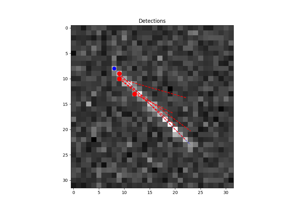
Designed for modularity, ATLAS can be uploaded to any satellite with a star tracker and a computer. The software runs parallel to the star tracker, taking images from it and processing them to detect poorly lit objects that would otherwise be below the star tracker’s brightness threshold. Processing can be done within minutes or seconds, Schmitt said, then the results are sent to the ground.
With this approach, “there is no need for the ground station to have any kind of input,” Schmitt said.
Beyond speeding up detection times and downlink speeds, Stellerian’s main focus for ATLAS is improving image processing to get as much information from as little input as possible.
To an orbiting satellite, nearby objects look like pixels of light against a dark backdrop of stars so “typically, when you are doing onboard detection, the point at which you can actually see that there’s an object is at a signal-to-noise ratio of around three to five,” Waldecker said. A ratio of five is “‘Yes, absolutely, I can see this thing,’” while a ratio of three “takes a little bit of work.”
In ground tests, ATLAS has been able to detect objects “at as low as around a one and a half signal-to-noise ratio,” Waldecker said. “We’re able to boost the brightness through the software to be able to see these things that typically would be invisible or typically would require a fancier sensor.”
“Theoretically, we could see all the way out to [geosynchronous orbit] from low-Earth orbit,” Waldecker said, but “at this point what we’re really expecting and hope to get out of it is a few thousand kilometers.”
For the software’s first on-orbit demo, Stellerian will pay to upload ATLAS to a satellite owned by another company that has yet to be announced, then use other imaging sources to “point in the right direction” of a known object, Schmitt said. Next, the company will use ATLAS to identify various objects and their trajectories, comparing the results to available ground-based imagery and previous on-the-ground performance models.
In preparation, Schmitt said the company’s engineers are trying to shorten the software’s image processing time and further expand its brightness detection threshold.
The main challenge Stellerian faces is whether “all of our simulated groundwork actually works in space,” Waldecker said. “You never know until you get up there.”
The demo is expected to last at least two to three weeks, but Waldecker hopes ATLAS performs well enough to be kept on board indefinitely and becomes “node No. 1 in our network.”
Once ATLAS is flight-proven, “we are looking to upload to as many satellites as we can,” either by paying companies to host the software or selling the software to customers, Waldecker said. The satellites “don’t have to be the same constellation. They don’t have to be [the] same manufacturer or anything.”
On one satellite, ATLAS can be used to avoid potential debris collisions, monitor formation flying and track objects maneuvering in unusual ways, but on a network of satellites, “we can completely replace ground stations,” Waldecker said.
“Currently, if you’re trying to track a satellite in space and you have a single ground station, you’ll see it on average maybe once every 12 hours,” he said. “With some of our studies, we’ve been able to show with even two dozen in-space nodes, we’re able to see every object in low-Earth orbit within 45 minutes.”
“What we’re doing for this long-range approach is to be able to see objects in space virtually at all times,” Schmitt added. “That’s going to be a game changer for vision in space.”