A 2027 lunar landing will put this navigation prototype to the test
Engineers at Sydney, Australia-based Advanced Navigation have designed a laser navigation prototype that could guide future spacecraft landings on the moon, and they’re now adapting the technology to build a sensor for drone navigation in GPS-denied airspace.
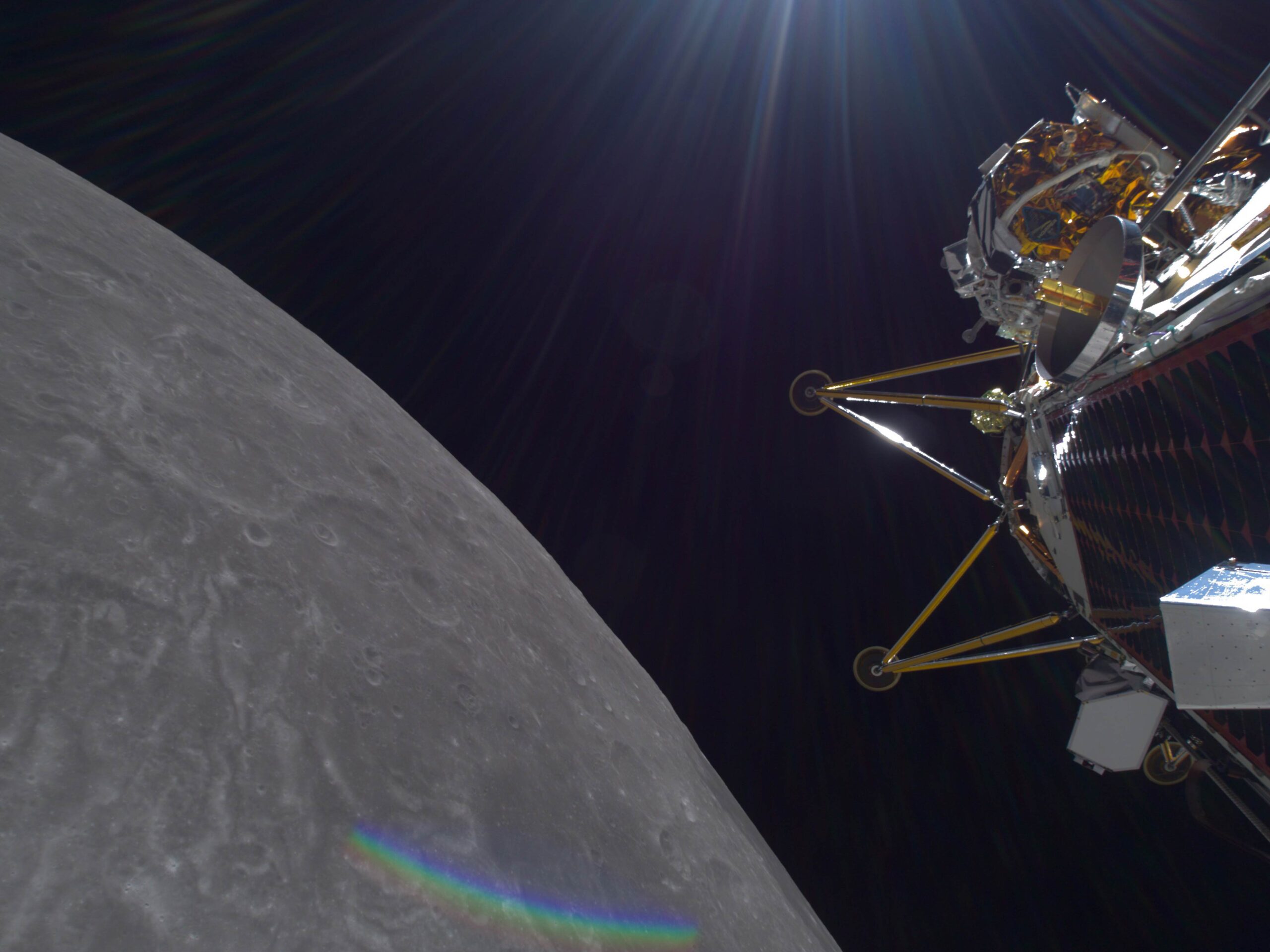
The lunar navigation prototype — dubbed LUNA, for Laser Unit for Navigation Aid — is set to be tested next year during Intuitive Machines’ IM-4 mission, the fourth such landing the Houston space exploration company is contracted for under NASA’s Commercial Lunar Payload Services program.
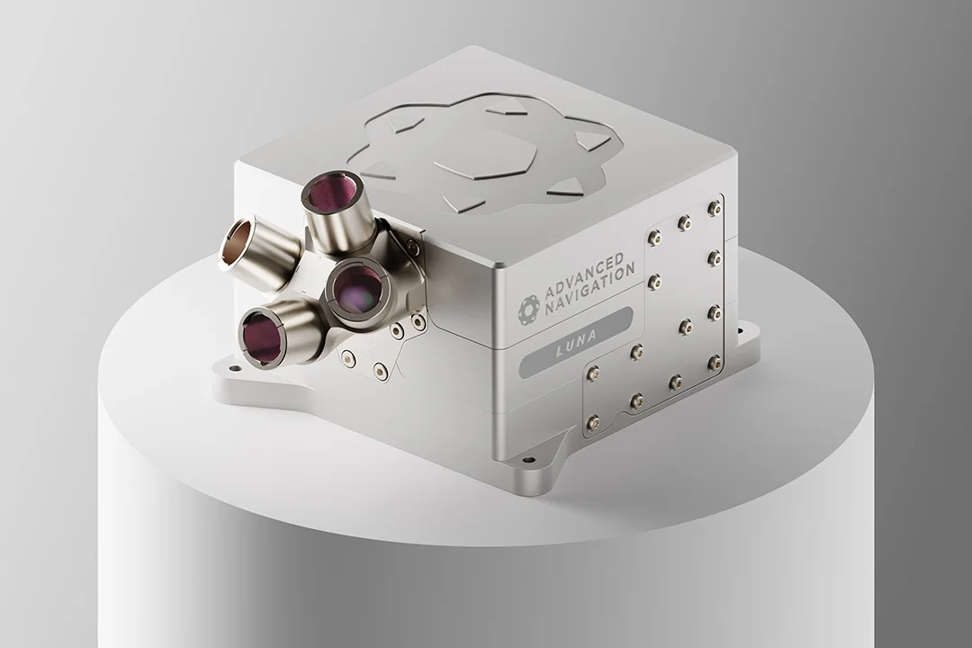
The completed LUNA device, which looks like a four-lensed camera jutting out of a box about the size of a six-pack of soda, is on track for delivery to Intuitive Machines later this year, said Joe Vandecar, head of product management at Advanced Navigation. From its position on the side of the lander, the device will not guide the IM-4’s descent and touchdown, but it will provide altitude and velocity readings as if it were. If proven capable, the device could guide the safe landings of future lunar spacecraft.
“These landing sensors are critically important,” said Tim Crain, chief technology officer and co-founder of Intuitive Machines, which faced laser navigation sensor problems on its first two lunar missions. Both the Odysseus lander on the IM-1 mission in 2024 and Athena on IM-2 in 2025 could not accurately judge their altitude upon landing and tipped over.
“All of our missions from now on are going to fly with multiple landing sensors, so that we have backups and we have redundancies,” Crain said. Also, to avoid a scenario where both the primary and backup navigation sensors fail for the same reason, each will be made by different vendors for future missions, starting with IM-3 that’s scheduled to launch later this year.
“The more lightweight, high-performance planetary landing sensor options that are out there, the better our supply chain looks,” he said.
An optical navigation system can accurately report a lunar lander’s lateral position by comparing its camera’s images to digital maps of the moon’s surface, but the spacecraft also needs laser sensors for calculating its altitude, Crain said.
Starting eight years ago, Intuitive Machines pushed for LUNA’s development, providing Vai Photonics, which created the device, performance targets for IM’s “dream” instrument, Crain said. Intuitive told Vai “we would like a sensor that measured to this distance and this accuracy and massed less than this many kilograms,” he said. “They did the rest.”
“When we started in 2018, if you asked me how many affordable, short-schedule, high technology readiness landing sensors were on the market, my answer to you would be exactly zero,” Crain added.
Advanced Navigation acquired Vai and the LUNA concept in 2022, and in 2023 received a $3.29 million (U.S. dollars) grant from the Australian Space Agency to develop LUNA. In addition to the Intuitive missions, the company sees a market for LUNA with the host of other companies planning robotic moon landings in the coming years.
LUNA shoots four laser beams toward the ground: One is a range finder to measure the distance from the spacecraft to the lunar surface; the other three measure its velocity in three dimensions — how fast the spacecraft is moving forward, left-or-right and up-or-down.
The laser range finder measures the time it takes for the beam to reflect off the ground and return to the sensor. The three velocity-measuring lasers also reflect off the ground, but the sensor measures the Doppler shift in the wavelengths of the reflected laser light.
As the spacecraft moves toward the point where one of the lasers reflects off the ground, the reflected light will have shorter wavelengths than the outgoing light, shifting bluer; if the spacecraft is moving away, then the returning light will shift redder on the spectrum.
By reading the magnitude of the wavelength shift for a given laser, LUNA calculates the spacecraft’s velocity relative to the laser’s reflection point on the ground. The sensor then determines the three-dimensional velocity by triangulating the three laser readings.
One of the key engineering challenges in developing LUNA was reducing its size, weight and cost, Vandecar said. In some cases, they turned to parts originally designed for other industries. For instance, by using a component developed for the telecommunications industry, engineers were able to shave 300 grams off while improving LUNA’s performance. They also reduced costs by adopting automotive and defense industry components, in addition to space-rated parts. LUNA weighs less than 4 kilograms, compared to 18 kg for legacy sensors, Vandecar said.
Ideally, Intuitive Machines would like a laser navigation sensor that begins measuring altitude at 10 kilometers, when the lunar lander begins firing its engines to slow it down for the descent; an error range of less than 1% while pulling less than 50 watts of power; ability to withstand temperatures of 50 degrees and minus 30 degrees Celsius; and a weight less than 3 kgs, Crain said.
Also: “I want the sensor to be smart enough to tell me when it’s not working.”
For IM-3, scheduled for between October and December, Intuitive Machines will install a four-laser-beam navigation sensor similar in concept to LUNA, with two single-laser range finders as backups, aboard its Trinity lander. The goal is to land with downward velocity of between 0.8 and 1.2 meters per second and lateral velocity of less than 0.2 meters per second. The IM-2 lander hit the surface at about 10 meters per second — an impact well outside what it was designed for, sending it skidding and rolling.
Advanced Navigation believes the LUNA concept can also be adapted for other purposes. Engineers have developed versions of the laser navigation sensors for air and land vehicles on Earth.
One of them, Chimera Air, could help small and medium-sized drones fly in battle zones where GPS signals are jammed or spoofed. A similar device for ground vehicles, Chimera Land, could help navigate in battle zones or other areas where GPS is not available, such as in underground mines.
For the LUNA and Chimera Air prototypes, the company has tested the laser velocity sensors by mounting them in a fuselage cut-out on a four-seat, single-propeller plane and flying them over desert, farmland and forests in Western Australia. During a 100-kilometer flight last year, a laser velocity sensor combined with an inertial navigation system device reported the plane’s position with a 29-meter error, without the aid of GPS. More test flights are planned for Chimera Air over the next few months, Vandecar said.
Like the four-laser concept for LUNA, Chimera Air and Chimera Land provide three-dimensional velocities for drones and ground vehicles, respectively. Those velocities are fed into an inertial navigation system device, or INS, to calculate the drone or ground vehicle’s position based on the path it has traveled from its last known location.
LUNA “was the brainchild that really spawned this technology,” Vandecar said. “The INS needs super-precise velocity inputs” to reduce errors that will compound over time. If, for example, a drone’s velocity is reported as 60 kilometers per hour when its actual velocity is 59 kph, then the position calculation will be off by 1 km after one hour of flight.
“The core problem a lot of our customers want to solve with our inertial navigation systems is being able to accurately position their system when GNSS [global navigation satellite system] is not available,” such as GPS, said Jai Castle, product validation lead at Advanced Navigation.
The company’s INS device, a black box small enough to fit in the palm of a hand, contains two gyroscopes and three accelerometers to measure motion and acceleration for up-down, left-right and forward-back. There’s also an algorithm for calculating position based on those measurements and other sensor inputs, including from the Chimera laser velocity sensors.
Advanced Navigation is marketing Chimera Land for underground mining vehicles and battlefield ground vehicles. For Chimera Air, the company plans to produce a prototype for potential defense contractor customers by October and a commercial version for sale by next year, Vandecar said.
The company demonstrated Chimera Land with its INS to the U.S. Army in September in a GPS-jammed environment at White Sands Missile Range in New Mexico and plans to demonstrate Chimera Air at a similar event this year.
As with LUNA, the engineering goal for Chimera Air is to reduce its size, weight, power consumption and cost so that it is suitable for drones as small as 10 kgs, Vandecar said. The device will weigh about 800 grams and be slightly larger than an iPhone.
Potential customers have shown an interest in Chimera Air’s “low emissions,” or lack of signals that could expose a drone’s position on the battlefield, Vandecar said.
“It’s very hard to detect, this technology,” he said. “It won’t be a massive beacon that says: ‘I’m over here.’”