

The increasing frequency and severity of large wildfires like the ones that devastated parts of LA in January have given fresh energy to researchers and companies who believe drones should play a much larger role in firefighting. Jen Kirby looks at the state of the technology and some of the promising applications.
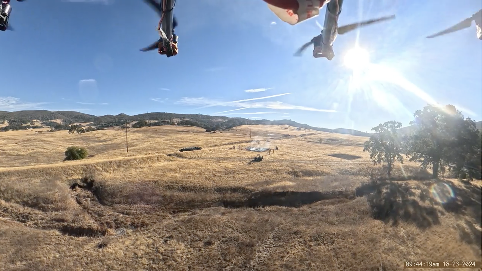
Picture it: All around you, a blue expanse of sky. Below, a landscape dominated by brown brush where, in the distance, tiny figures stand around a rectangle billowing smoke. The sun is shining so brightly, your reflex is to squint — except this is just a video, recorded from the belly of a drone.
This footage came from a drone flight conducted last year by Zhaodan Kong, an associate professor of mechanical and aerospace engineering at the University of California, Davis, over McLaughlin Natural Reserve. This Northern California nature reserve is about 200 kilometers south of Paradise, the site of the 2018 Camp Fire that caused some $12.4 billion in damage — the costliest wildfire in U.S. history until the Eaton and Palisades blazes in the Los Angeles area earlier this year, according to the National Fire Protection Association.
The flights were the latest in Kong’s ongoing trials to determine which instruments aboard a drone could most quickly detect any nearby fires — in this case, a planned and well-monitored controlled burn. For this particular 2024 test flight, the octocopter was equipped with three modules: a camera to visually track the plumes of a burning fire; an infrared camera that could capture images even through heavy smoke; and, finally, chemical sensors to “sniff out” plumes of smoke in low-visibility conditions, like at night or when a fire is still far away. Together, the sensors would provide visuals of a fire and its GPS coordinates to help firefighters determine how best to eliminate it.
Kong’s drone is just an early prototype, but it offers a glimpse into new ways that these small aircraft could be deployed to help prevent, detect, monitor and suppress wildfires, which are igniting more frequently and burning more intensely as Earth’s climate continues to warm. Firefighting groups across the U.S. already use drones in a range of scenarios, from managing prescribed burns to overhead monitoring of active fires, but innovations like Kong’s could make them an even more valuable tool in the firefighting arsenal.
“I think there’s a very good application for them,” says Bob Roper, senior policy adviser to the Western Fire Chiefs Association, of drones. “Are they the end-all to replace all the staffed aviation? No. Do they have an application in certain situations where manned equipment is? Very definitely.”
Kong is designing his drone with early detection in mind, envisioning it as a kind of aerial patrol that could be stationed in the skies during times of high fire risk — say, particularly dry or windy conditions — to survey an area and provide real-time updates. If deployed in large numbers, the drones could be a way for firefighters to monitor remote areas that are difficult to reach by other means, including those out of view of fixed cameras or watch towers. They could hover above a location, tracking smoke plumes and capturing images in more detail than what’s possible with geostationary satellites, and with GPS data attached.
The more drones that could be deployed, the better chances “you’ll be able to detect the fire in a large area very quickly,” Kong says.
“Very quickly” is the key. The earlier that crews know a fire has ignited, the sooner they may be able to control or extinguish it, potentially preventing massive conflagrations that burn thousands of acres, threaten property and lives, and cost tens of billions in economic damage. In other words, stop the next Eaton Fire or Palisades Fire before it can spread far enough to warrant a name.
“The shorter latency we have between the occurrence of the fire and us picking it up — it significantly diminishes the future impact,” says Ankita Mohapatra, an associate professor in the electrical and computing engineering department at California State University, Fullerton, who is researching and developing early wildfire detection techniques.
While specific trends vary from region to region, a general pattern is emerging: The typical fire season is expanding due to a range of factors. A warming climate can increase droughts and dry out landscapes, which means more fuel available to burn. Fires are burning more intensely and causing more damage. From 2003 to 2023, there was a 2.2-fold increase in the number of extreme fires, according to a 2024 paper published in the journal Nature, “with the last 7 years including the 6 most extreme.” The authors based their conclusions on some 20 years of observations by NASA’s Aqua and Terra satellites from their sun-synchronous orbits. In this context, “extreme” refers to a variety of factors, including a fire’s intensity and ecological impact, including how much smoke and carbon dioxide it emits.
Once ignited, such blazes can be extremely destructive because so many communities are in wildfire-prone areas. According to the Wildfire Risk to Communities website maintained by the U.S. Forest Service, as many as 115 million Americans live in fire-prone counties — about one-third of the entire U.S. population.
“For many places that especially make the news, it’s what I refer to as the confluence of climate, people, and fuels, and they’re all very connected,” says Tim Brown, research professor in climatology and director of the Western Regional Climate Center at the Desert Research Institute, a nonprofit in Nevada.
The researchers, scientists, practitioners, and startups I interviewed are all in general agreement about the wildfire threat, but views differ about where drones could make the greatest contribution. Kong is among those who see an opportunity in early detection, while others are proponents of using drones to put out nascent fires or for aerial monitoring to support active firefighting operations — or some combination of all of these.
“I don’t think that our solution is able to solve the entire problem,” Kong says of his monitoring drone. “I think we need to attack this particular problem from multiple fronts.”
Stopping ‘the big one’
A round, bright green pod sits in the middle of an otherwise empty storage unit, like an alien spaceship secreted away. The black solar panels arrayed along the retractable upper shell make it look like a cross between a turtle and an enormous golf ball.
This pod is really just a hangar, the resting place for the main event: a slender, baton-shaped drone with thin black legs, wings fixed at its sides. This is Silvaguard, a prototype from Dryad Networks unveiled earlier this year. The German company is developing the drone to track and give precise coordinates for wildfires — and, eventually, extinguish small fires autonomously.
Carsten Brinkschulte, Dryad’s CEO, and Pedro Silva, the company’s chief technical officer, showed off the drone to reporters at their headquarters in Eberswalde, a city about an hour outside of Berlin that is known for its forests. (“Wald” means “forest” in German.) That makes it a pretty good spot to test the possible future of wildfire-fighting tech, though the Silvaguard prototype did not make a flight during my visit.
The drone builds on the company’s current product, Silvanet. These solar-powered sensors with built-in artificial intelligence — each roughly the size of a smartphone — are hung from trees to quickly detect carbon monoxide and other gases emitted by a fire. Dryad trains the AI-enabled gas sensors in its lab in Eberswalde, where researchers ignite forest floor samples to hone their “electronic nose,” as Dryad’s Brinkschulte describes it. The lab is lined with labeled glass mason jars filled with twigs and leaves native to certain places — a Spanish forest, or a German one, for instance.
Every minute, the sensors test the air, and if they sniff something that might be a fire, do the machine equivalent of rapid breathing to confirm if something is smoldering. Each Silvanet sensor can cover about one hectare, and they are connected to one another through a mesh network — an “internet of trees.” During a test I observed in the forests near Eberswalde, the first sensors detected a fire about five minutes after it was lit.
“Now that we can detect the fire within minutes, we thought, ‘Hey, why don’t we take the next step, and act on it?’” Brinkschulte says.
That’s where the Silvaguard drone comes in. If one or more Silvanets detect a fire, a signal is sent to the hangar pod so it can open the roof. The pod does a few environmental checks — testing things like wind speed — and essentially clears the drone for takeoff, its flight plan determined by the general area identified by the sensors. If the Silvaguard, equipped with an optical and infrared camera, detects something that might be a fire, it can hover above that area and confirm, recording the size, temperature and images of the blaze.
“This is supposed to trigger another sequence, which is an extinguishing sequence,” says Silva. That process of snuffing out the fire is still a work in progress, he notes, and Dryad is experimenting with different ways to accomplish this, including with water, foam and sound waves.
“We need to take it down to the whole detection and response within 10 minutes to be really effective,” Brinkschulte says. “We think it can only be achieved with an autonomous drone system. I don’t think that human-based response will ever get to that speed.”
Other researchers share that objective of shrinking the time between detection and suppression. At the University of Bristol in England, professor Sabine Hauert and her team are studying whether they can do so with a swarm of drones. Hauert imagines that during high-risk seasons, this drone swarm could be dispatched — like a flock of birds all programmed to work together — to search for fires, using image and thermal cameras to autonomously detect any flames. If it does, the swarm could then reorganize into firefighting mode and drop an extinguishing payload onto the flames below.
“They can continue to reorganize to make sure they’re still covering the space to look for other fires that might pop up,” Hauert says.
They’re currently testing a Windracers ULTRA drone, made by the U.K.-based Windracers, a design capable of traveling longer distances and carrying heavier payloads.
Like Dryad with its Silvaguard, Hauert envisions the swarm having a large degree of autonomy. “You imagine the fire swarm operator on the ground that sees what’s happening from the swarm, sees information about the fire and has that level of control — but a lot of the decision-making and algorithms is happening on the robots themselves,” she says.
Drones on the front lines
The early detection drones in development by Hauert and others illustrate possible future applications of these craft, but they’re largely tailored to the very early stages of firefighting — stopping nascent and still-small fires in their tracks, rather than combating larger or rapidly spreading fires. For those later-stage tasks, drones likely won’t be able to work alone.
Peter York is the California Department of Forestry and Fire Protection’s battalion chief for UAS (uncrewed aerial systems) Operations. About five years ago, the department, known as CAL FIRE, began assessing how drone technology could assist in all kinds of operations, from wildland fires to water rescues. The goal was never to replace humans on the ground or assets such as piloted aircraft, he says, but to find ways to reduce the risks to them or complement their work. In his experience, drones have been most useful for providing actionable intelligence and situational mapping, such as details on the perimeter of a fire.
“UAS has been invaluable in providing real-time intelligence to our folks on the ground when there’s not crewed aviation over the top that have that same capability,” York says. “We’re able to do it right at the back of the pickup truck with the TV over the shoulder, looking at the controller and providing — just right now, these are the exact conditions that are going on in front of you or in front of your forces.”
He adds: “We’re the high-end, technical lookout.”
For CAL FIRE’s drones, such short-range reconnaissance missions are the sweet spot, adding critical context to urgent operations, including the ones the public never hears about. York calls these the “five-acre” fires that typically don’t make the news. According to CAL FIRE, 95% of California’s wildfires are contained at 10 acres or less. Crews stop the fires fast, with help from piloted aircraft and other aerial equipment, and then people on the ground contain the fire.
“And that’s where we’re able to provide them with really good information about what they have on the ground and what maybe they can’t see,” York says, adding: “That’s the win for us.”

When it comes to extreme fires — the ones that do make the news — York and his teams use the same mapping techniques, just on a larger scale. For the Palisades Fire, for instance, York says they logged some 65 hours of flight time, with around 200 sorties. About 10 drone pilots were assigned to the Palisades Fire, and six to the Eaton Fire.
These large fires also bring additional logistics and operations challenges. When a blaze is threatening to spread unchecked, drones could add to an already overcrowded airspace that includes the larger piloted aircraft trying to douse the flames or drop retardant to stop the spread.
But with careful management and coordination, drones still have a role. Often, pilots can dispatch them to areas of a fire where crewed aircraft aren’t, so they can feed information to supervisors. Other times, the drone pilots work alongside supervisors who may ask them to fly over and investigate certain areas. York says that in rare circumstances, the CAL FIRE UAS division will alternate flight times with other aircraft so drones can be sent up to get an up-to-date site picture.
Ultimately, York says, it’s however the technology can best serve the ultimate goal of stopping the wildfire. “We’re providing a real-time intelligence product to those folks, but we do that very strategically and systematically.”
Finding their niche
For all their potential, drones have their limitations, too. Octocopters and other small, consumer designs are ideal for hovering over specific locations to deliver precise images and GPS coordinates, yet that also translates to shorter flight times. These drones often can’t travel long distances or loiter for long without coming back to base. Flight times are also dependent on factors including environmental conditions, like heavy winds, all of which adds up to little margin for error in operations. One challenge Dryad Networks has encountered in testing its drone: training the Silvaguard to maneuver among trees to drop its fire-suppression payload — then get back out — without ramming into branches along the way.
Another key challenge is seamlessly integrating drones alongside piloted aircraft. “Both industries — the man and the unmanned — are still kind of like that junior high school dance where everybody’s looking at each other,” says Roper, the Western Fire Chiefs Association adviser. “They’re trying to figure out, ‘Where do we go?’”
Seasoned wildfire crews are good at what they do, and the reality is that not every new technology will make their jobs easier. Throwing too much technology at a problem might be counterproductive.
“You have to coordinate your air, your manned air resources, with what people are doing on the ground, to support those firefighters on the ground,” says Paul Petersen, executive director of the United Aerial Firefighters Association, which represents the aerial wildland fire industry. “To just put UAS up without providing a tangible benefit to the firefighters on the ground, it’s like lighting the other side of the road on fire. You’re really not helping the situation at all.”
Logistical challenges play a role here as well, because the internet connectivity that many drones require may be unreliable or even nonexistent, especially in remote areas. It can also be difficult to manage airspace in low visibility situations, something NASA is attempting to address through its ACERO project, short for Advanced Capabilities for Emergency Response Operations. In March, researchers tested their suitcase-sized portable airspace management system, designed to share and display the locations and planned flight paths of all crewed and uncrewed aircraft operating in a particular scenario. In areas with poor internet connectivity, PAMS can rely on radio communications.
In the end, what might prove the most challenging is adopting all this new technology at scale. Prototypes and field tests can help demonstrate the capabilities of drones, but if firefighters are to rely on them — especially autonomous designs — their efficacy needs to be proved before departments spend dozens of hours and thousands of dollars integrating the craft into their tried-and-true operations.
Complicating matters is that, as Petersen says, there is no large, centralized program on the federal level — think DARPA for wildfires — dedicated to studying and testing new technologies. The adoption of drones and related technology is likely to happen in fits and starts, or on an ad hoc basis.
Yet he believes drones and other innovations will increasingly become integral to fighting wildfires. “If we didn’t try new technology,” Petersen says, “we’d still be fighting fire with burlap sacks and buckets.”
