
Global conflicts expose GNSS vulnerabilities, inspire innovation
Civil and military aviation face major challenges to global navigation satellite systems (GNSS) integrity. The war in Ukraine has turned GPS denial from a theoretical risk to a tactical norm. Uncrewed aerial systems (UAS) and munitions misnavigating under jamming or spoofing are reported daily on frontlines. Aerospace systems developers are responding to the call for solutions, building systems that are resilient by design — capable of resisting interference and, in some cases, exploiting it without disrupting commercial operators. Yet critical advances are still needed to safeguard global airspace.
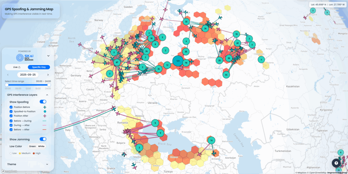
You can’t defend what you can’t detect, so detection is the first imperative. In January, SkAI Data Services launched a live GPS Spoofing and Jamming Tracker Map that uses ADS-B data to identify and geolocate jamming activity. The following month, Zephr.xyz won a U.S. Air Force Research Laboratory contract to deploy smartphones with networked software in Ukraine to map jamming and infer interferer locations. And in the February issue of the journal Remote Sensing, Jin et al. described a method using antijamming array antennas to detect spoofing and estimate source direction.
Survivability and continuity remain the second line of defense. In May, Sine.Engineering announced a fivefold production scale-up of its navigation modules for drones that use hybrid algorithms to maintain control under spoofing or jamming. In June, Calian GNSS launched its Controlled Reception Patterned Antenna (CPRA), bringing null forming and advanced filtering to a compact form factor. Keysight followed with a white paper in August outlining how to certify CRPA performance in regulated environments.
Defense original equipment manufacturers (OEM) are also hardening platforms for the battlefield. In January, Israel Aerospace Industries integrated its ADA antijamming system with M-code GPS receivers, boosting resilience for military aircraft and UAS. In September, RTX’s Collins Aerospace delivered the first NavHub assured Positioning, Navigation, and Timing (PNT) solution hardened with M-code to Europe — the first noninternational Traffic in Arms Regulations navigation system of its kind.
Fallback navigation gained urgency as well. In June, Daedalean and MOOG demonstrated GPS-free autonomous navigation over a 70-nautical-mile flight, closing the control loop after deliberate GPS shut-off midflight. The same month, Inertial Labs/VIAVI unveiled a visual-aided inertial navigation system to maintain positions in GNSS-denied airspace.

Visual and inertial fusion can falter in featureless terrain or poor visibility, driving interest in next-generation solutions. In August, DARPA launched its Robust Quantum Sensors program to transition ultra-low drift inertial devices from laboratory demos to rugged prototypes. Q-CTRL was awarded two contracts under the program after flight tests demonstrated its quantum-assisted MagNav system achieved significantly lower positioning error in GPS-denied environments.
Regulators responded, though unevenly. Throughout the year, FAA issued multiple advisories and GPS interference Notice to Airmen (NOTAM), reflecting that disruption is now a routine operational hazard. Airlines rerouted flights in Europe and the Middle East after GNSS anomalies triggered cockpit alerts or autopilot disengagement, showing the substantive cost of false or unavailable positioning.
Meanwhile, some systems are being designed to turn GNSS denial into an advantage. In February, Kvertus introduced its Atlas counterdrone jammers — rapidly iterated from combat feedback —followed by the Berserk robotic electronic warfare system. In June, DroneShield announced a record $61.6 million European contract to supply GNSS denial systems aimed at disrupting UAS navigation in target areas. These systems illustrate how interference is now an operational weapon.

Global conflicts have presented the harshest test yet of GNSS resilience and a warning to aviation that satellite services can no longer be taken for granted. Closing the remaining gaps through fast detection, robust continuity and layered navigation is imperative. As regulators move toward assured PNT and new standards, defense agencies are already fielding solutions. As threats evolve, these advancements may enable aviation to sustain safe operations even under interference.
Opener image: An October 2025 view of SkAI’s GPSWise Spoofing and Jamming Map. Circles mark affected areas, with numbers showing spoofed aircraft. Background grid cells show jamming intensity, and darker red indicates stronger interference. Credit: SkAI Data Services
