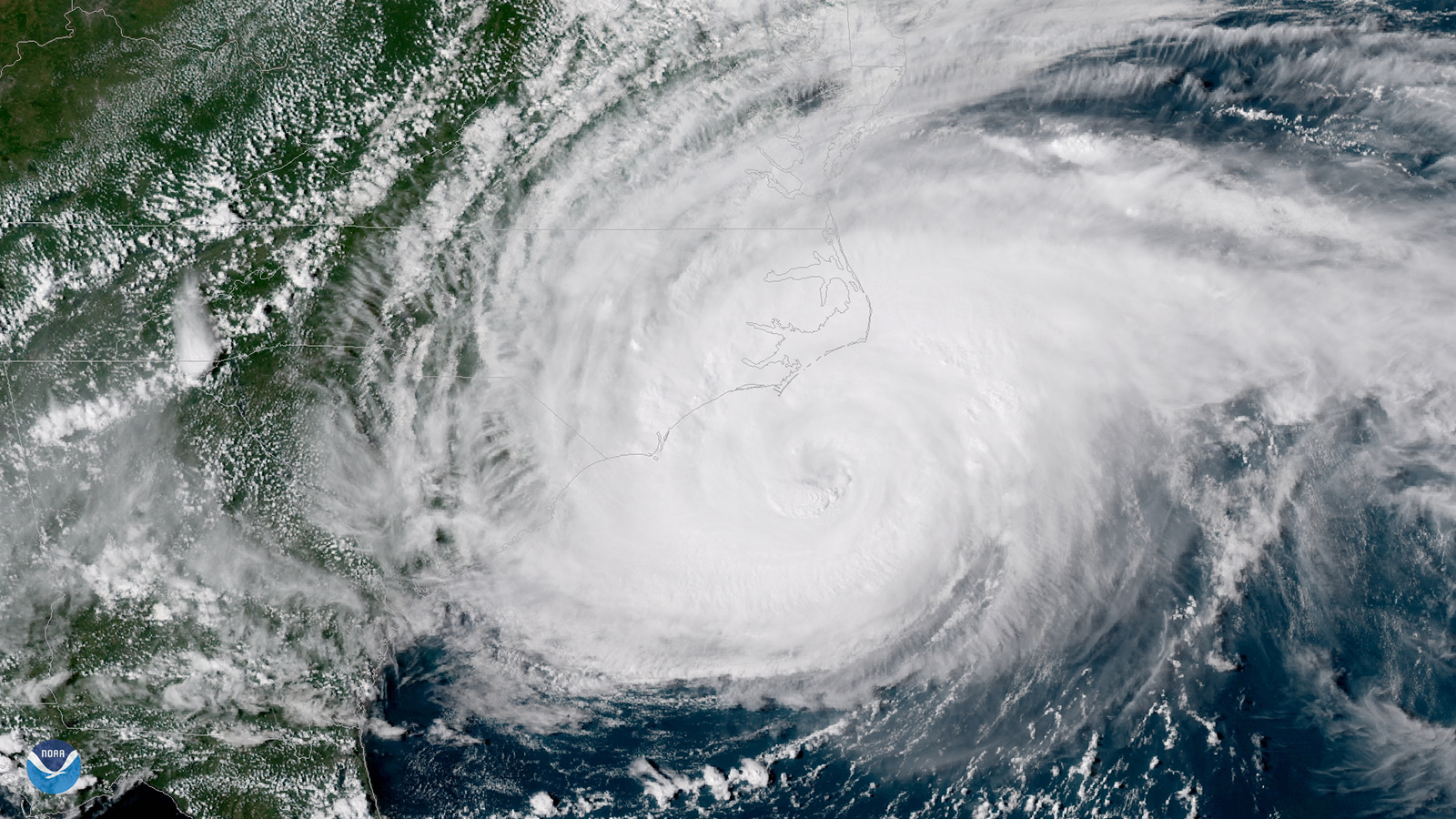
The Advanced Baseline Imager on NOAA’s GOES-16 satellite delivered the dramatic photos and videos of the hurricane.
The closeup videos of Hurricane Florence’s swirling eye that mesmerized online and TV audiences last month came from a satellite camera of an entirely new design that was still in its checkout phase last hurricane season.
The Advanced Baseline Imager, built by Harris Corp., is the primary camera on NOAA’s GOES-16 weather satellite, which is positioned in the GOES-East slot 36,000 kilometers over the equator. From this position, ABI can see the Atlantic Ocean all the way to the coast of Africa and a bit beyond.
ABI scans across Earth by rotating two mirrors, one to control the north-south line of sight and the other to control the east-west line of sight. The concept is a bit like the sideview mirrors of your car, which let you adjust the view from side to side and up and down, explains Paul Griffith, chief engineer in Harris’ Environmental Solutions unit in Fort Wayne, Indiana, where the ABI cameras are built. “ABI does this with two sets of mirrors,” he says in an email forwarded by a spokeswoman.
The camera delivers a full disc image of the Western Hemisphere every 15 minutes and can also scan two smaller sectors when commanded by the National Weather Service. Forecasters can examine two separate storms at one-minute intervals, or in rare cases the two sectors can be “stacked” at one geographic location to produce images of a single storm every 30 seconds, explains NOAA research meteorologist Dan Lindsey. He is the senior scientific adviser in the NASA office that manages development of NOAA’s newest Geostationary Operational Environmental Satellites, the GOES-R series.
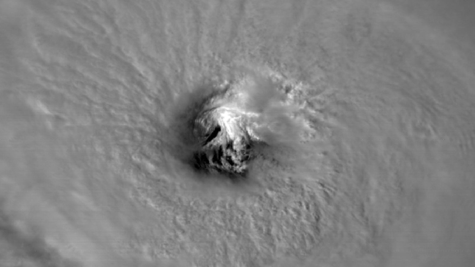
Some of the most intriguing Florence videos were produced by this 30-second method. The resulting images are “close to snapshots,” Lindsey explains. “It’s sort of like time-lapse photography from space,” he says.
The process of creating a video begins once the scans are downloaded from the satellite and disseminated. Lindsey or anyone with a data feed can apply software to set parameters, such as how much to zoom in.
The videos are smooth because ABI captures imagery five times faster than its predecessors, the GOES Imagers. Were it not for this high temporal resolution, the videos would appear choppy. ABI also provides four-times finer spatial resolution, which is why swirling low-level clouds, called mesovortices, were so clear in the eye of Florence in some videos. Specifically, the images are built from pixels (picture elements) about 500 meters on a side, depending on the storm’s latitude, which determines the distance from the camera.
As enthralled as the public was by the motion of the clouds around and within Florence’s well-organized eye, hurricane forecasters also tend to tune in much earlier in a storm’s development. They need to locate the center of circulation to initialize the various forecast models, and that can be tricky when a storm is weak. “With the one-minute updates,” Lindsey says, “it’s a lot easier to sort of track the low-level clouds and infer where the center is located.”
In the NOAA image at the top of the page, the eye of Hurricane Florence is visible on Sept. 11, three days before the storm made landfall at Wrightsville Beach, N.C. The image is a screen shot from a NOAA video.