
Solving Florida’s red tide mystery
Scientists are far from ready to conclude that human pollution from the Florida mainland has been fueling the growth of a poisonous red tide algal bloom along the state’s Gulf of Mexico coast, my interviews with scientists show.
“Right now, no one can forecast the onset of these blooms” with certainty, but “it may be possible to predict the likelihood of a bloom,” says Chuanmin Hu, a professor of optical oceanography at the University of South Florida who develops satellite remote sensing algorithms to study human influences on coastal water quality.
Hu says satellite instruments have their limits and that more water sampling is needed to define the precise conditions that trigger naturally occurring Karenia brevis algae to explode into toxic red tide blooms. The bloom in Florida over the last 10 months has killed thousands of fish, including goliath groupers, and also dolphins and sea turtles along Florida’s southwest coast. Earlier this month, Florida Gov. Rick Scott declared a state of emergency.
Sea surface temperature measurements from the Moderate Resolution Imaging Spectroradiometer on NASA’s Aqua spacecraft are among the sources of historical context for studying the origin conditions and movements of K. brevis, Hu says. NASA, NOAA and European groups also collect sea surface height data from the Jason-3 satellite, whose Poseidon-3B altimeter bounces radar signals off Earth’s surface to calculate ocean wave height and wind speed.
One obstacle to solving the mystery is cost. Researching Florida’s coastal water to predict how blooms originate and grow “is not cheap,” Hu says. “If you want to research the onset of blooms you have to know the coastal areas very well,” and “that is a huge area,” he says.
For some environmental groups in Florida, the cause of this particular red tide is not so mysterious. They blame periodic discharges of dirty, blue-green algae-rich storm water from Lake Okeechobee, visible in images from ESA’s Sentinel-2 satellite, into the Caloosahatchee River and ultimately the Gulf of Mexico.
On that point, a NOAA funded study into a massive 2005-06 red tide, “Karenia Brevis: Nutrient Dynamics in the Eastern Gulf of Mexico,” has generated some confusion, says oceanographer Quay Dortch, who manages NOAA-funded research into causes of harmful algal blooms. The study listed the decay of “blue-green alga” as the top source of nutrients for that bloom, but the study also referred specifically to Trichodesmium, a saltwater variety distinct from the freshwater green-slime that occurs in Lake Okeechobee and the Caloosahatchee River and dies when it reaches the Gulf.
Dortch says evidence of human pollution fueling offshore blooms “isn’t as clear cut as it is for the inland blooms.” Further study is needed to determine how much humans are contributing.
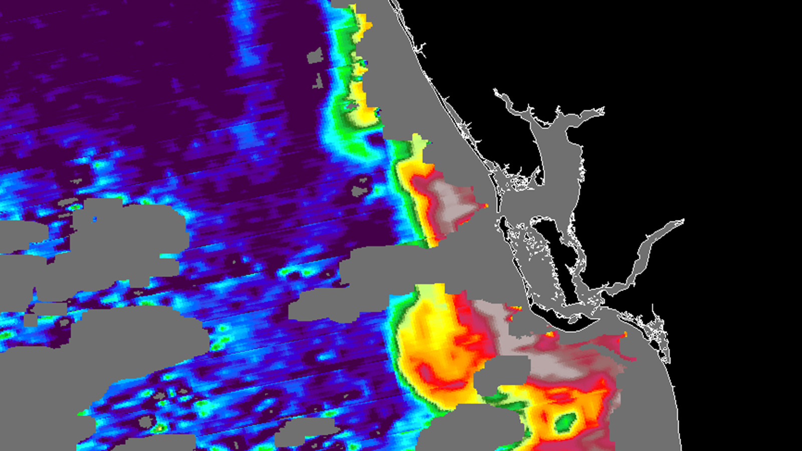
In the image from the University of South Florida at the top of this page, the red and yellow concentration at the lower right of the map shows high levels of chlorophyll from red tide algae offshore from Fort Myers on Florida’s southwest coast. Researchers at the University of South Florida created this map from an image taken on Aug. 27 by the Moderate Resolution Imaging Spectroradiometer instrument on the NASA Aqua satellite, which detects solar-stimulated fluorescence, the light emitted by chlorophyll molecules.
NOAA estimates harmful algal blooms cost the U.S. an average of $82 million every year because of impacts to public health, tourism and the seafood industry, so the Senate Subcommittee on Oceans, Atmosphere, Fisheries, and Coast Guard has scheduled a hearing on Tuesday to address the effects of harmful blooms and research about them.

