Weather forecasters are always hungry for more data. Over the last few years, they've learned that signals from GPS and rival constellations can tell them interesting things about the atmosphere. The question is whether cubesats and other smallsats can gather these radio occultation readings accurately enough. Debra Werner takes the measure of a congressionally directed pilot project that could provide the answer.
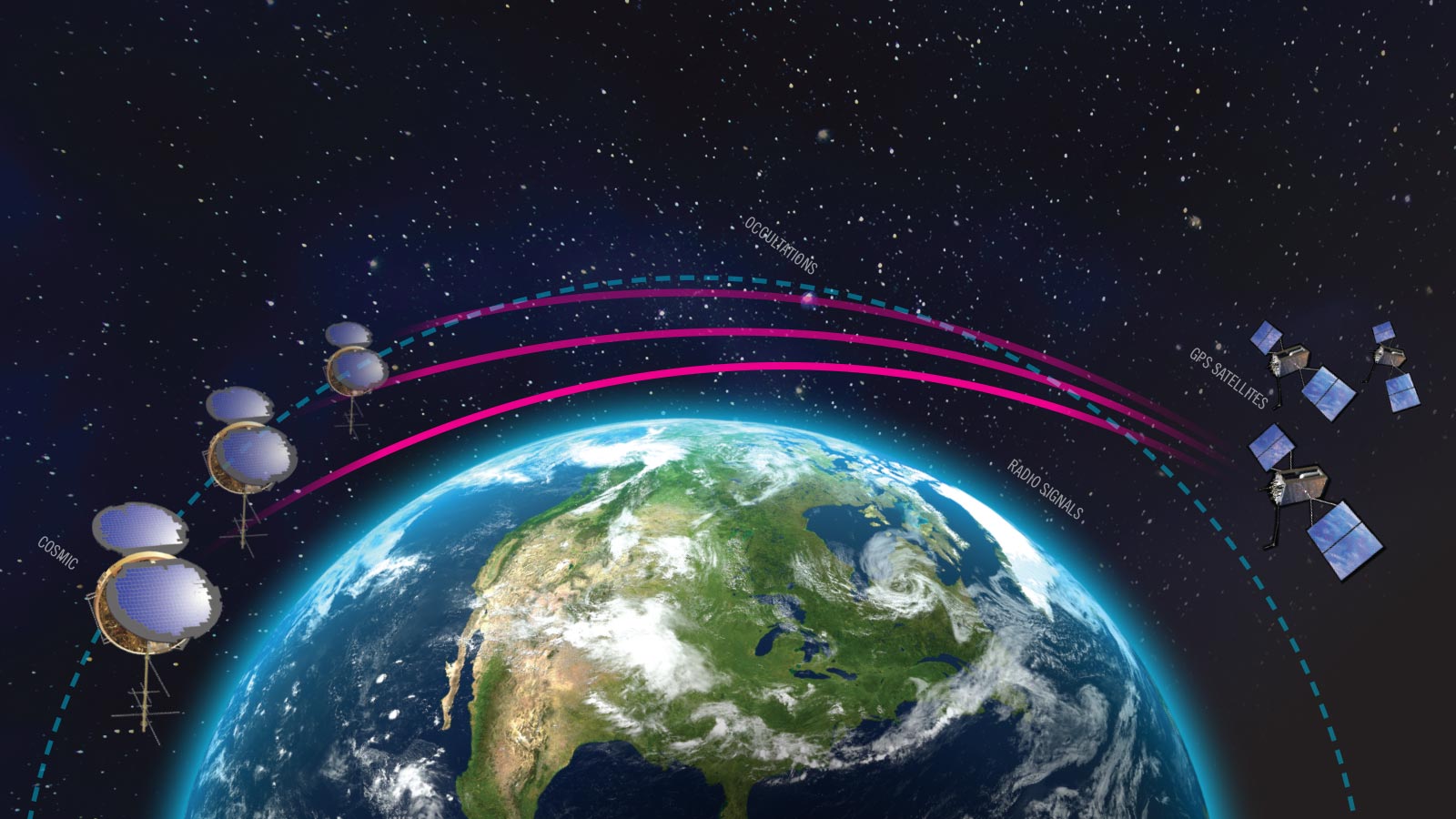
When radio waves pass through a planet’s atmosphere, the molecules and electrons bend the waves not unlike how a piece of glass or body of water refracts light. The denser the atmosphere, the more bending. NASA scientists famously put this principle to work in 1965 during the Mariner 4 mission. After passing Mars, the probe transmitted radio waves back toward Earth with the red planet partially blocking, or occulting, the path. This assured that some of the radio waves passed through the Martian atmosphere. The technique, called radio occultation, gave scientists their first precise measurement of the density of the Martian atmosphere.
Flash forward five decades, and Earth is now ringed with a constellation of 24 GPS satellites, plus rival constellations operated by China, Europe and Russia. Some microwaves from these satellites plow through the atmosphere including cloud cover to reach users on the ground, but some inevitably radiate past the curve of the Earth and into space. An instrument orbiting on the other side of the globe can catch these navigation signals. From the degree of bending, software on the satellite or on the ground can deduce moisture content, air pressure and temperatures at various altitudes, with each set of data called a sounding.
Scientists have long been intrigued by this technique, called radio occultation, but as recently as a decade ago, they were unsure of its precision in the lower atmosphere.
A turning point came after Typhoon Nuri struck the Philippines in 2008, explains meteorologist William Kuo of the University Corporation for Atmospheric Research, a Boulder, Colorado, nonprofit focused on research and training forecasters and young scientists. The storm originated in an area of the Western Pacific Ocean that was shrouded in clouds that blocked the view of the lower troposphere for weather satellites that rely on traditional microwave soundings to chart temperatures by measuring microwave energy emitted from the atmosphere and surface. Weather balloons, in theory, could have given clues about what was happening under the clouds, but the Pacific Ocean is vast and no balloons were in the area. U.S. and European weather models did not capture the moisture under the clouds and failed to predict the formation of Nuri, which exploded into one of the year’s strongest cyclones.
After Nuri, researchers led by Kuo were curious to see whether radio occultation could have shown the models what lay under the clouds. They acquired archived radio occultation readings of that area of the Pacific taken during Nuri’s formation by a constellation of NOAA and Taiwan-funded technology demonstration satellites called COSMIC, for Constellation Observing System for Meteorology, Ionosphere and Climate, and other satellites. Kuo and his team discovered that by adding radio occultation measurements from GPS into the forecast model, they could see spiral rainbands associated with the developing storm. The model was now able to predict Typhoon Nuri.
The Nuri study, often presented by scientists at conferences with a video of the decloaked rotation, helped NOAA and Taiwan’s National Space Organization win funding in 2010 and 2011 for a second generation of COSMIC satellites.
Small-sat entrepreneurs jump in
Now, entrepreneurs in the U.S., aided by a NOAA-managed pilot project, are racing to bring radio occultation to market and do it with smallsats and cubesats that are just a fraction the size of the COSMIC satellites.
Despite early setbacks, these entrepreneurs retain an unshakeable conviction that the technique can revolutionize forecasting and earn them a sizable share of what could be a multibillion-dollar global market for various kinds of commercial weather data, including radio occultation soundings.
NOAA, on orders of Congress, is doing what it can to nurture the industry through the 2-year-old Commercial Weather Data Pilot project. In September, NOAA awarded a total of $8.3 million in second-round contracts to three weather satellite startups: GeoOptics of Pasadena, California; PlanetiQ of Golden, Colorado; and San Francisco-based Spire Global. Their occultation readings will be fed into offline forecasting models so that results can be compared to those from operational models.
NOAA is hoping for better results this time than from the first round of the pilot in April 2017, when the agency did not receive enough soundings to assess the technology. GeoOptics, which received $695,000 in the first round, didn’t launch any satellites in time to meet the deadline. Spire, which received $370,000, provided some observations but not enough for a full assessment. NOAA decided to add PlanetiQ for the second round.
“We saw enough promise coming out of the first round that we knew it was worth at least doing round two,” says NOAA’s Karen St. Germain, a microwave remote sensing expert. “I am optimistic about it. They are probably going to get to a good capability that can be a part of the overall NOAA observation portfolio moving forward,” St. Germain adds. She directs the Office of Systems Architecture and Advanced Planning within NOAA’s National Environmental Satellite, Data and Information Service, the agency that feeds observations from satellites and weather balloons into supercomputers running forecast models that the agency shares with meteorologists.
Watching all this closely are U.S. forecasters who are hungry for more and more occultation soundings, provided the accuracy of the data can be verified in part with the aid of COSMIC. In terms of forecasting value, the soundings from COSMIC have been “right up there with satellite infrared and microwave soundings, radiosondes and aircraft reports,” says Joseph Pica, director of the National Weather Service Office of Observations.
Fine-tuning multiday forecasts
Forecasters evaluated numerical weather models with and without COSMIC data and found the additional temperature and moisture data had the largest impact on multiday forecasts, providing the quality of a four-day forecast eight hours in advance and a seven-day forecast 15 hours earlier, says Lidia Cucurull, an atmospheric physicist and deputy director of NOAA’s Quantitative Observing System Assessment Program.
At its height, the COSMIC constellation produced 1,500 to 2,000 atmospheric soundings per day. Each sounding reveals pressure, temperature and humidity in an atmospheric column. Now, only one of the six COSMIC satellites works at all and it operates intermittently, which is why NOAA is preparing to launch a second COSMIC constellation.
If meteorologists had 100,000 radio occultation soundings, that “would double forecast accuracy,” predicts Peter Platzer, chief executive of Spire Global, which in 2015 became the first startup to operate a constellation of radio occultation cubesats.
While that degree remains to be shown, the forecasters I interviewed agreed that a higher number of soundings would improve forecasts dramatically, particularly in the Southern Hemisphere and over the oceans, areas that don’t receive as much attention from geostationary weather satellites or weather balloons.
NOAA will gauge the accuracy of the commercial observations gathered under the pilot project, while the Joint Center for Satellite Data Assimilation, a research agency serving NASA, NOAA and the U.S. Defense Department, will assess their impact on forecasts.
“Different vendors may well deliver occultation observations that have different performance characteristics,” says St. Germain. “We want to understand the value they can provide.”
Much of St. Germain’s optimism can be traced to COSMIC. In 2011, the European Center for Medium-Range Weather Forecasts studied the value of various weather model inputs by removing specific datasets and gauging the impact on forecasts. When researchers compared forecasts with and without radio occultation, they found that the additional observations reduced forecast error by 10 percent. That impact reportedly impressed them, because radio occultation satellites provide only 2 to 3 percent of the observations fed into the forecast models.
A similar 2010 study by NOAA’s National Center for Environmental Prediction revealed radio occultation had the third highest impact per observation on a NASA Goddard Earth Observing Systems weather model behind radiosondes and ship buoys.
Pointing to that evidence, NOAA won congressional support for the second COSMIC constellation. COSMIC-2, a six-satellite constellation scheduled to launch into an equatorial orbit on a SpaceX Falcon Heavy rocket in 2019, possibly as early as April or May, will feed data directly into numerical weather models. If all goes according to plan, six COSMIC-2 satellites will capture a total of 5,000 soundings per day between 40 degrees north and 40 degrees south latitude, where much of Earth’s population lives. Those observations will be fed into forecast models within 30 minutes.
Within that coverage area, COSMIC-2 is focused on the tropics because that’s where the atmosphere holds most of its moisture and moisture “drives the global weather engine,” says Bill Schreiner, the COSMIC project director for the University Corporation for Atmospheric Research in Colorado.
COSMIC-2 is a paired-down version of the constellation that was originally conceived in 2010. At that time, managers envisioned following the first tranche of six satellites orbiting over the equator with a second six-satellite constellation, dubbed COSMIC-2B, with the satellites crossing from pole to pole. The United States and Taiwan canceled plans in 2017 to build those satellites, because neither government was willing to fund them.
Congress pushes for commercial sources
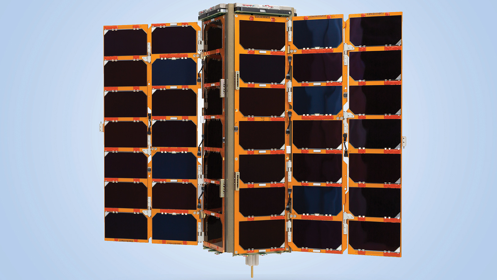
By the time COSMIC-2B was canceled, entrepreneurs were designing and building radio occultation cubesats and, in Spire’s case, operating them. The trend toward miniature electronics means companies can fit radio occultation receivers and powerful processers into satellites of 5 to 18 kilograms compared to the original COSMICs, each of which weighed about 70 kilograms. The new COSMICs will be even larger, at close to 300 kilograms, because each will carry redundant electronic components and extra scientific payloads. Congress, seeing progress on the commercial side, pushed NOAA to compare the cost and capability of commercial constellations with government satellites.
In a report accompanying a 2017 appropriations bill, Congress asked NOAA to provide a detailed comparison of the cost of acquiring radio occultation data from the COSMIC-2’s polar-orbiting constellation, including development, launch and operations, with commercial data sources, a comparison that led to the demise of COSMIC-2B.
Schreiner, the project director at the University Corporation for Atmsopheric Research, was sorry to lose COSMIC-2B. “It would have allowed us to provide excellent improvements to weather forecasting and to monitor the quality of commercial systems,” he says. “There is plenty of room for commercial data. Studies show significant impact from radio occultation even when you have 100,000 soundings per day.”
Entrepreneurs, on the other hand, were pleased Congress pushed NOAA to support their fledgling ventures. Jim Bridenstine, the Oklahoma Republican who was a member of the House of Representative’s Space, Science and Technology Committee before becoming NASA administrator last year, led the congressional campaign for commercial radio occultation.
Bridenstine found ready allies in the industry. “There’s no question you get more for your money with a commercial service,” says retired U.S. Navy Adm. Conrad Lautenbacher, a former NOAA administrator who now leads GeoOptics. “Federal government funding is essential for research, but the commercial sector is the most cost-effective provider of proven products and services.”
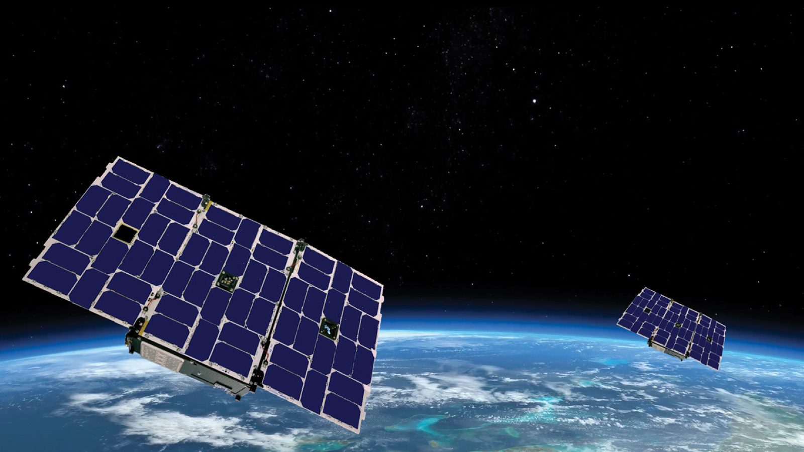
As of Dec. 5, Lautenbacher’s company was operating three 10-kilogram Cicero radio occultation cubesats with sensors it developed with the NASA-funded Jet Propulsion Laboratory and Tyvak Nano-Satellite Systems, a small spacecraft builder in Irvine, California.
GeoOptics’ shoebox-size satellites “produce data that compares very favorably with COSMIC-1 data,” Lautenbacher says.
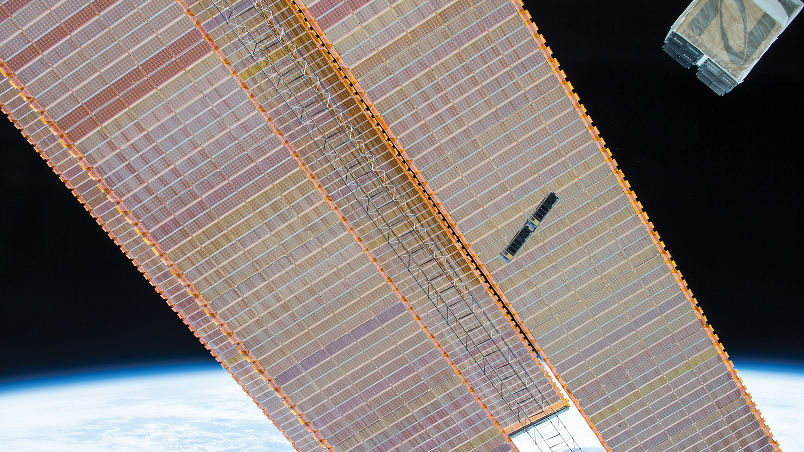
Spire, meanwhile, operates a fleet of about 71 5-kilogram cubesats that it calls Lemurs. Each is equipped with radio occultation sensors in addition to Automatic Identification System receivers for maritime tracking. Spire also began installing Automatic Dependent Surveillance-Broadcast receivers for airplane tracking in its new cubesats in 2018.
“Our three-unit cubesats, the size of a wine bottle, track the weather, ships, planes and a whole bunch of other things,” Spire’s Platzer says. “They have higher-gain antennas than COSMIC-1 and two to three orders of magnitude more processing power.”
PlanetiQ has built three radio occultation satellites but not yet launched one. If all goes according to plan, PlanetiQ’s 12-unit cubesats, built to track radio signals from GPS as well as Russian GLONASS, European Galileo and Chinese BeiDou navigation satellites, will begin launching in 2019.
“We’ll get three up toward the end of the year on three different launchers,” says Chris McCormick, PlanetiQ founder and chairman.
McCormick, who led Broad Reach Engineering when it built radio occultation receivers for COSMIC-1, Germany’s radar satellite TerraSAR-X and TanDEM-X, and others , is confident PlanetiQ’s commercial receivers will outperform COSMIC-1’s.
COSMIC-1 receivers were built in 2004, meaning the technology was selected around 2002.
“Sixteen years later, a lot of other things are better from an instrument perspective,” McCormick says. “Our antennas are actually bigger than COSMIC-1 antennas. We’ll have better signal-to-noise ratio, faster computers and we’ll be tracking most of the Global Navigation Satellite System signals not just GPS.”
The most striking difference between commercial radio occultation satellites and their government flown counterparts is the volume of precise, geographically dispersed observations they could potentially provide for weather and climate models. McCormick compares it to adding pixels to improve the resolution of an image. Worldwide, agencies launch 1,800 weather balloons, measuring temperature, pressure and humidity in an air column. In contrast, one PlanetiQ satellite will gather 2,500 soundings per day.
“We’ll get more soundings with one satellite than all the weather balloons and we are going to be launching 18 satellites,” McCormick says. That, says McCormick, is what’s needed to improve the precision and accuracy of forecasts.
Radio occultation: How it works
Sensors mounted on satellites travelling in low Earth orbit continually observe radio signals broadcast by global navigation satellites in medium Earth orbit. For example, satellites in the Constellation Observing System for Meteorology, Ionosphere and Climate, launched in 2006 by NOAA and Taiwan’s National Space Organization, orbiting 800 kilometers overhead acquired signals from GPS satellites in 20,200-kilometer orbits.
Each COSMIC satellite observed a GPS signal for about three minutes or one occultation before the spacecraft passed behind Earth where it could no longer see the GPS spacecraft. Software on the satellites and in ground stations measures how the atmosphere refracts GPS signals, providing precise observations known as soundings that reveal atmospheric temperature, pressure, density and water vapor in an atmospheric column.