
Kate Calvin, NASA chief scientist and senior climate adviser
Kate Calvin is the 11th chief scientist at NASA, but the first to juggle an additional mandate. She is also the agency’s first permanent senior climate adviser. In that role, she must carry out the Biden administration’s pivot to prioritizing the study of Earth’s changing climate and the search for ways to lessen its impacts of that warming. That involves elevating the profile of NASA’s Earth-observing satellite programs, some of which the Trump administration attempted to stop funding. She also strategizes with NASA’s communications office about how to share this data with the general public. Here’s our conversation, condensed and lightly edited.
Q: How does combining the roles of chief scientist and senior climate adviser reflect how NASA is prioritizing climate research?
A: The reason that we’ve combined the roles is to lead with climate science, and the roles are very similar in the sense of the kinds of activities that are going on. So as senior climate adviser, I’m connecting climate across the agency. We have research and technology development at different centers at different parts of the organization, and I’m trying to connect that and amplify that and work with interagency partners and international partners to coordinate on those efforts and make sure that they know what NASA is doing. We can also help facilitate their use of NASA information. As chief scientist, I’m doing those same sorts of tasks but with the broader science portfolio — trying to connect it across the agency and communicate that externally and work with other agencies and international partners on things related to science more generally. We work with some of the same agencies on broader science and then also on Earth science, so sometimes it’s just about talking to a different part of different agencies.
Q: In terms of the strategy for emphasizing climate research, how much is it about starting new programs versus connecting existing programs back to the topic?
A: On Earth observations, we have decades of data that we’ve collected about vegetation, temperature, precipitation, clouds, carbon dioxide. And because we’ve been observing this for a long time, we can see both the state of the Earth today and also how it’s changed. We use this information in our models to help us understand drivers of change and also where we might go in the future. We have applied science programs that work with different stakeholders to provide Earth observing and other applied science information that can help support local responses. So before, during and after disasters occur, we can provide information on the ground to help support that. We can look at where wildfires are burning, emissions and air quality associated with fires. We can look at burn perimeters and burn scars. We are also developing technologies that help mitigate or adapt to climate. Our aeronautics team has been working for a while with the aviation industry to help reduce fuel use and emissions. Then in our space operations directorate, we know that living in space and operating in space present challenges that could have applications on Earth. We grow crops in the International Space Station, and some of the things that you develop to grow a crop in space have benefits on Earth. NASA scientists have worked to develop LED lighting that’s now used in indoor agriculture facilities. There’s a lot of work like that going on, and part of my job is trying to connect that and communicate that.
Q: What are some of the space technologies you’re interested in finding Earth applications for?
A: The water processing system on the International Space Station. Some of the technologies used for that water processing have been used on Earth to help provide clean water in places where it’s harder to get. NASA scientists have also worked on formulating fertilizers that reduce runoff. They try to get nutrients to the plant roots at the rate they need it, and that reduces runoff, which has implications for water quality on Earth. We’ve also made fertilizers that are more precise, so more nutrients are absorbed by the plants, and less are going into rivers and streams. We’ve developed sensor technologies to sense things in outer space that could also be used to observe Earth. For example, the sensors used in the James Webb Space Telescope informed the development of sensors used in the Orbiting Carbon Observatory missions, which measure carbon dioxide on Earth.
Q: What you’re describing sounds like a way for NASA to advance technologies related to climate change without sacrificing its diverse range of programs.
A: It’s important that we still explore space. We can learn a lot about Earth by observing other planets. Venus is thought to have been habitable once, but it’s now very, very hot. Some of the research on the greenhouse effect on Venus and ozone on Venus has informed what we know about the greenhouse effect and ozone depletion on Earth. Similarly, our several rovers and the helicopter exploring Mars will hopefully help us understand better the climate changes that Mars has undergone and how they apply to Earth as well.
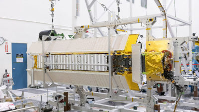
Q: On Earth observations, some of those satellites have been operating for decades now. As NASA looks at upgrading the fleet, what technologies are you excited about?
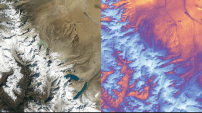
A: There are programs where we continue to collect the same sort of data, just better and better over time. We just in September launched Landsat 9, and we’re coming up on a 50-year record of Landsat. I just saw a display of results from Landsat earlier this week. They showed land use in the same space from the beginning of the Landsat record to today so you can observe the land use and land cover change — which is what Landsat is designed to study — and changes in vegetation. But you also see the improvements in these satellites. You get finer and finer resolution and better-quality data over time. We are also designing a new Earth System Observatory, a set of satellites that are designed to work together to provide a 3D holistic view of the earth. The first one, NISAR [NASA-Indian Space Research Organization synthetic aperture radar] will look at changes in the Earth’s surface in a way that’ll help us understand changes in ice sheets and ice sheet collapse and changes in landslide and other surface dynamics. The more we understand about the planet and how it’s changing, the more we can give people information that they can use to respond to it. So we’re continually trying to expand the observations. We get that data out to people who can use it, and we provide support and training on data. We’re trying to continually make it more accessible — not just the data but also the science. We work with local stakeholders and decision-makers through our disasters program area in the Earth Science Applied Sciences Program to help support this. For instance, with the VIIRS [Visible Infrared Imaging Radiometer Suite] instrument on one of our polar-orbiting satellites we can look at power outages: You can see the lights at night, and that gives you a sense of where you have power outages from a storm. You can use other instruments to look at changes in the land surface from tornado tracks or burn scars. And you can put all that together. The more information we provide about Earth and the more we can help people use it, the more informed decisions they can make.
Q: What’s still missing in your climate modeling?
A: There are questions around clouds and climate change and trying to get at how much will the Earth warm for a given level of emissions. One of the satellite missions that is coming up later this year is called SWOT [Surface Water and Ocean Topography], and it’s going to look at surface water and oceans. It’ll give us the first complete survey of water running through rivers and lakes. In my old research, we were looking at how water scarcity might change over time. In order to get at that, you have to know how much water people need for energy or agriculture or other activities but also how much water is available. And we don’t really have a complete sense of that right now, much less how that’ll change in the future. So something like SWOT is really important for understanding that and better constraining models and giving us a sense of how that might unfold in the future. SWOT’s also going to look at oceans, which play a really, really important role in climate change because they absorb heat and carbon. How the ocean mixes and circulates affects how much more carbon it can uptake and how much more heat, which has implications for future climate change.
Q: You mentioned how the Landsat data has gotten more refined. How do you ensure data continuity so scientists are still able to compare the new datasets with measurements taken decades ago?
A: This is something that scientists have been dealing with for a while. So when you look at something like temperature records, we have information from surface stations that go back years. Before that, we have information from tree rings and ice cores. Scientists spend a lot of time thinking about how we can make this all work together to make a more complete picture so that you have a longer time series of information. Exactly how you do that depends on the data that you have and what you’re working with. One part is just being really clear about what you’re showing. Are you looking at surface temperature, meaning the actual temperature of the Earth itself, or are you looking at temperature 2 meters above the surface? That’s something we’re communicating more publicly; often to the public we just say temperature, but among the scientific community, it’s really important to be precise about exactly what you’re measuring. Then when you use a model, you want to run it over historical periods so you can see how it compares. You can use information from satellites to better understand your model and to constrain your model.
Q: You touched on public perception of climate change, which hasn’t shifted much in the past five years, according to a Gallup poll done in early March. How do you respond to skeptics?
A: NASA enjoys a broad public trust and support for science. Our science shows that climate is changing. We’re seeing warmer temperatures. There are more extreme events that come along with that, so we’ve seen more heat waves and extreme precipitation events and wildfires associated with that. We communicate that to the public broadly. We have lots of different avenues to get information out: social media, news releases, materials for children. Part of building trust and communication is being transparent and open, and this is why NASA is really pushing on open data and open science. All of our satellite and observation information is already readily available to the public, but we’re working on making it easier to use and showing not just the data but how we got there. One of the things that I really appreciated watching the last couple months is the news releases and web posts about the James Webb Space Telescope. We’ve been showing along the way what’s happening, what it takes to get a telescope like that out to its orbit and producing science images. That’s really important in communication: to show what’s happening and be very transparent about the whole process, not just the end result.
Q: Looking across NASA, what’s a big topic or trend that is going to shape the science goals in the coming years?
A: I would say two things. One is we do have a lot of really exciting Earth science missions coming up. I mentioned SWOT that will help us understand rivers and ocean. We have NISAR that’s going to help us understand changes in air surface, like landslide and ice sheets. We also have TROPICS [Time-Resolved Observations of Precipitation structure and storm Intensity with a Constellation of Smallsats], a set of six satellites that will measure temperature, humidity and precipitation in the tropics. The EMIT [Earth Surface Mineral Dust Source Investigation] instrument will be put on the exterior of ISS to help understand mineral dust, which has implications for local climate and air quality. Second, the Artemis program is starting. I’m really excited about the human and robotic efforts to explore the lunar surface. I’m excited to watch the Artemis I mission this year.
