It’s time to replace those hurricane cone graphics
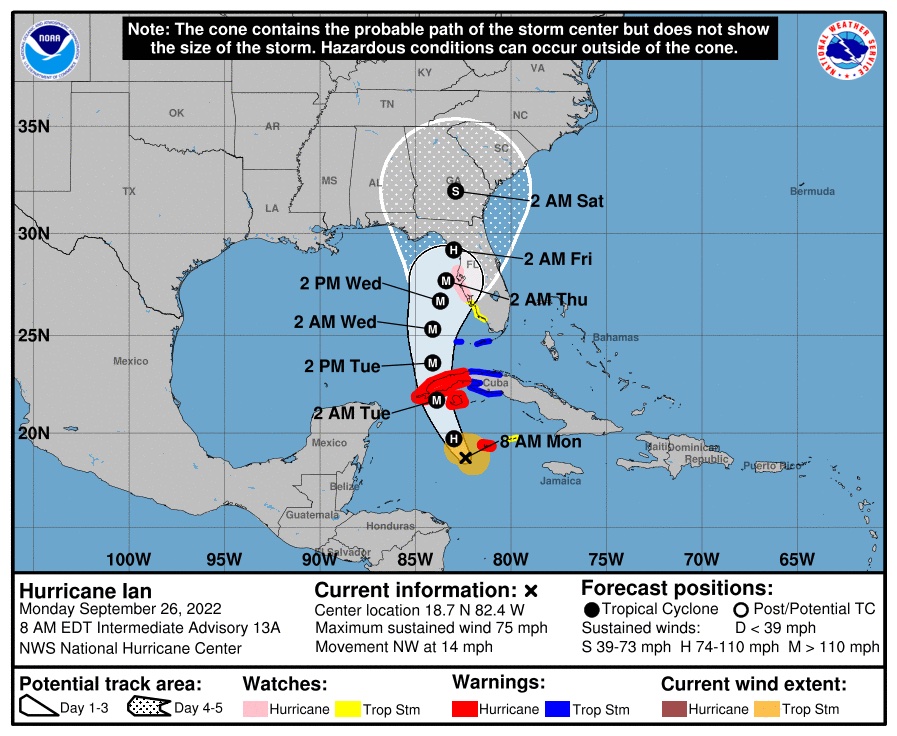
Each hurricane season, terabytes of temperature, humidity and pressure collections from satellites and hurricane hunter aircraft are fed into forecasting models and ultimately boiled down into the famous hurricane forecasting cones published online by the National Hurricane Center and adapted by local television forecasters.
The collective experience with those cones this hurricane season should prove once and for all that the cones are a dangerous failure as a communications tool. When Hurricane Ian plowed into the west coast of Florida in September, too many residents either ignored warnings to evacuate or decided that local authorities issued them too late to do so.
The decision about whether to leave is a complicated one. Evacuating is expensive. False alarms are common. Getting back home after a storm can be hard. So, every bad decision should not be attributed to the hurricane cones alone. But no one wants to evacuate, and the cones sometimes provide false justification for staying.
Here’s how: The spread of the cone depicts the uncertainty about where the center of the storm will go as forecasters look to the future. So far, so good, but then the Hurricane Center puts a string of black dots in the middle of the cone to represent the center, or eye, of the storm and its probable track. That’s part of the communications mistake. Here at Aerospace America we make a lot of graphics, and those dots are exactly the tactic I would recommend if the goal were to draw the viewer’s attention to the center of the cone, rather than the entirety of it. The implication is that if the track isn’t aiming for you, there’s no need to leave.
For public safety, the goal should be to draw the viewer’s attention to the uncertainties. Forecasters are never certain of the path days ahead, or even that the path will stay in the cone. About a third of the time, it doesn’t, and Ian was almost one of those cases.
“The landfall location of Hurricane Ian’s center ultimately stayed within or on the edge of the cone throughout the forecast cycle,” said Jamie Rhome, acting director of the National Hurricane Center, in an in-house writeup. The center’s media shop directed me to this page when I asked to speak to a cone expert, explaining that there is “high demand” for interviews about the cone after Ian.
The cones also feed our fixation with the impressive winds around the center of a storm. As Ian shows, we ought to be focusing at least as much, if not more, on the frightening bulge of water that a hurricane drives toward a coastline. This storm surge proved to be the most deadly aspect of Ian. Warnings of the surge were given, but not on the cone graphics that are so iconic for those living in the danger zones.
There must be a better approach, and hopefully the center is working on one. My idea would be to shift to four arrows that would cover the same span as the old cones. Each arrow’s shape would gradually spread to reflect growing track uncertainty ahead in time. Why four arrows? Because then there’s no center line to fixate on. Those arrows could be laid on top of a representation of the surge potential. This way, the surge and potential paths of the storm would be shown on one graphic. For those who have to know where forecasters think the eye is most likely to go, that information should be released as text on the center’s website.
That’s just one idea, and there are probably better ones. Whatever happens, the Hurricane Center needs to move away from highlighting the center track on television screens in every tiki bar in a storm’s potential path.