Climate change threatens to breed more extreme hurricanes. Adam Hadhazy describes how the innovations of unmanned aircraft, alongside conventionally crewed Hurricane Hunters, plus small satellites and next-generation big sats, could help forecasters get a better bead on what’s to come.
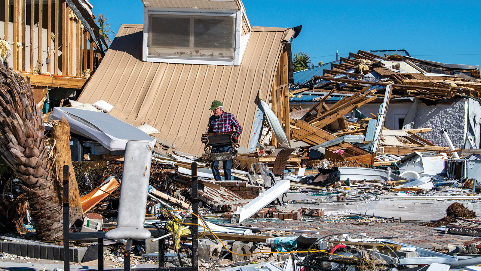
For U.S. forecasters, Hurricane Michael was right out of a nightmare. What started the day as a concerning Category 2 storm in the Gulf of Mexico morphed overnight into a catastrophically powerful, borderline Category 5. Michael’s rapid intensification caught forecasters completely off guard. When the hurricane plowed into the Florida Panhandle on Oct. 10, 2018, it did so as the fourth-strongest storm to ever hit the continental United States, devastating the region with maximum sustained winds of 155 mph (249 kph).
Hurricane Michael is emblematic of the challenges ahead for hurricane scientists in the balance of the 21st century. Although forecasters have made tremendous leaps over the last generation in the accuracy of predicting a storm’s track, predicting intensity — and thus a hurricane’s destructive power — remains frustratingly difficult.
Complicating the picture further is climate change. Warmer ocean waters act as a hurricane’s fuel source and will likely lead to stronger storms on average, with more growing into dreaded Cat 4s and 5s, as well as greater rainfall, studies show. The conditions could also make rapid intensification — defined as maximum wind speeds increasing by 35 mph (56 kph) within 24 hours, demonstrated by Michael — alarmingly more common, adding incentive for researchers and forecasters to learn how to identify those storms that will intensify.
Are humans and their carbon dioxide emissions to blame for raising the forecasting stakes so high? “The balance of evidence says we are most definitely impacting tropical cyclones,” says James Kossin, an atmospheric research scientist at NOAA’s National Centers for Environmental Information. How much and what’s to come are open questions.
And so, each hurricane season researchers engage in a high-tech storm-chasing gambit in hopes of acquiring revelatory details about the internal structures of hurricanes. The data could improve intensification models and help researchers gauge the degree to which climate change has put a figurative thumb on the intensification scale.
These new views are coming from high altitudes and also down low. Drones could ply the low-altitude interfaces in hurricanes, where raging sea and turbulent atmosphere meet and spawn conditions too dangerous for even Hurricane Hunter aircraft to venture. Meanwhile, new generations of satellites will provide an ever-keener high-altitude view of tropical cyclones. These spacecraft range from the conventionally bulky and high-powered, to the smaller and more numerous, designed to unprecedently probe storms in essentially real time.
“Rapid intensification is one of the top challenges in hurricane science,” says Scott Braun, a research meteorologist at NASA’s Goddard Space Flight Center in Maryland. “There is growing evidence that climate change will impact the occurrence and intensity of storms, but one question is whether we are seeing those effects now with storms like Harvey, Maria and Michael, or whether those influences won’t emerge until later in this century.”
Hurricane history
In assessing the storms of now and of the future, the starting point is, of course, the storms of the past. The U.S. started keeping official hurricane records for Atlantic storms in 1851. Yet compared to modern logs, those of yesteryear are woefully incomplete, limiting the available historical baseline for hurricane comparisons.
“Before satellites, if a storm didn’t interact with a ship or an island, there was just no way to know it was there,” says Kossin. Accordingly, hurricane counts have spuriously skyrocketed in the Space Age, which scientists factor in when studying trends in frequency.
As for intensity, Chris Landsea, the chief of the Tropical Analysis and Forecast Branch at NOAA’s National Hurricane Center, has thought about this. “The raw hurricane record is biased substantially toward an undersampling of numbers and intensities,” he says. “It tells you nothing about real climate change.”
Taking this into account, hurricane scientists have built up a substantial modern database, with extrapolations to the past. The granular detail available for storms continues to expand with each hurricane season. The following might feel counterintuitive, but to allow apples-to-apples comparisons for longer-term climate change monitoring, researchers must intentionally pare away some of this modern detail.
“We do a very careful recalibration of satellite data,” says Kossin, “basically degrading its quality to the spatial and temporal resolution of 1980 data, creating a homogenous dataset.” That nearly 40-year record, Kossin says, suggests that hurricanes are on average increasing slightly in strength. It’s a troubling trend, especially in light of sea-level rises that will render storm surges in the future more inundating and destructive.
Where nitty-gritty detail from modern instruments is helpful, however, is in understanding hurricane mechanics on ever smaller scales relevant to intensification. Those scales go down to even individual clouds of raindrops and ice particles within a tropical system. “Smaller scales tend to be much more chaotic in nature and therefore much harder to predict,” says Braun, compared to the large-scale winds in the environment of the storm.
Observations from satellites and the Hurricane Hunter aircraft, along with improved forecasts models, have made these macro-level influences “fairly predictable on time scales of about a week, and sometimes longer,” says Braun, leading to the dramatic improvement in storm track forecasts. The task at hand: to elevate intensity forecasting and long-term trend forecasting to the precision gained for storm tracking.
Aerial investigations
For more than seven decades, Hurricane Hunters have flown right into the most powerful storms on planet Earth. This weather reconnaissance could increasingly become the realm of robots, though, rather than brave aircrews.
The Air Force maintains a fleet of 10 Lockheed WC-130s, a modified version of the C-130 Hercules transport plane, that serve as Hurricane Hunters. NOAA’s dedicated planes are two Lockheed WP-3D Orion turboprops, nicknamed Kermit The Frog and Miss Piggy. The agency also scrambles a Gulfstream 4-SP, dubbed Gonzo, above storms to monitor air currents.
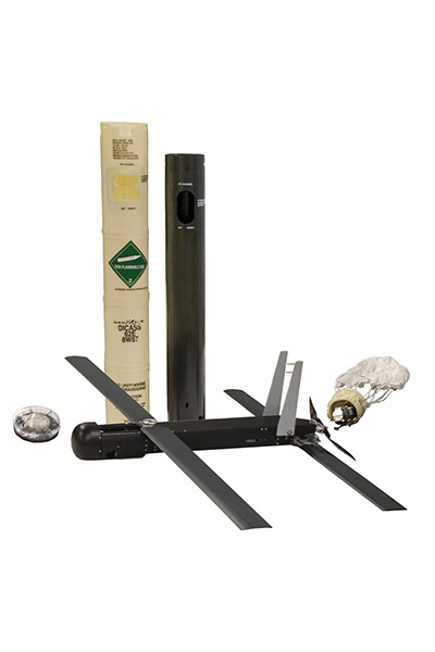
Though Hurricane Hunters do yeoman’s work, researchers hope to augment their abilities with drones. These craft could be deployed en masse, sampling storms with greater granularity at low cost. Drones can also go into the dangerous and difficult-to-access zone under 3,000 feet and even near the ocean’s surface. This critical, yet little-explored zone is where air and water intermix, exchanging energy between the ocean and the atmosphere, ultimately revving the storm. Drones “may be able to give us winds near the ocean surface like we’ve never had before,” says Landsea.
Leading the way is the 3-kilogram Coyote, an expendable, electrically powered drone developed by Raytheon. First deployed by NOAA in 2014, Coyotes fall out of sensor tubes on Hurricane Hunters. Their 1.8-meter wings unfurl, and the drones flit about inside hurricanes for upward of an hour. That’s far longer than traditional dropsonde sensors which, after being dropped out of the same tubes, can gather only a few minutes’ worth of temperature, pressure and humidity data before crashing into the ocean. Hoovering up all this information could build out models of intensification, teasing out variables potentially impacted by climate change.
“Unmanned aircraft certainly have a role to play in helping to define features of the hurricane and near-hurricane environment that may be important in explaining rapid intensification,” says Thomas Knutson, a research meteorologist at NOAA’s Geophysics Fluid Dynamics Laboratory in Princeton, New Jersey. “Some of these features are related to things which we also expect to change with climate change.”
Drones are bit players for now, but could soon become co-stars. “I don’t think we’re going to be replacing manned aircraft in the next few years,” says Landsea. “But perhaps in a generation we would be using fleets of both low-endurance, low-altitude small aircraft as well as high-endurance, high-altitude aircraft.”
The view on high
The advent of satellites did more than completely change the game of hurricane forecasting and preparedness. They also transformed public perception by delivering the familiar overhead shots of vast, white vortices scouring across land and sea. NOAA’s latest Geostationary Operational Environmental Satellites are now providing insightful new vistas.
Two out of a planned four in the latest GOES series have been launched. The Harris-built Advanced Baseline Imagers, the primary instrument aboard GOES-16 and GOES-17, look down at Earth through 16 spectral bands — two visible, four near-infrared, and 10 infrared, compared to just five for their predecessors. These imagers also provide four times greater spatial resolution and five times faster coverage, meaning the new GOES can snap detailed, successive images of a region of storm activity as little as half a minute apart. “They represent a big leap forward in our ability to observe on the large scale, both in terms of the resolution and the temporal sampling,” says Landsea. The upshot is better dynamic modeling of hurricanes’ evolution, improving forecasts and feeding into models of storm behavior in conditions potentially altered by climate change.
Another new element of the current generation of GOES sats are the first lightning mapper instruments in geostationary orbit, the GOES Lightning Mappers made by Lockheed Martin. While hurricanes generally produce little lightning, its relative frequency is being explored as an additional means of probing the storms, not unlike a novel test for a particular substance in the blood serving as a marker of disease severity.
Rise of the smallsats
As in many other aerospace applications, small satellites could prove promisingly disruptive for hurricane studies. The miniaturization of imaging technologies, power systems, navigation and orientation components, along with falling launch costs, is leading to remarkably capable, yet cheap machines for remote sensing in low Earth orbit.
Numerous demonstrations of small satellites are planned or underway. “Smallsats offer a lot of potential,” says Braun, “although we are still in the very early stages of evaluating their ability to deliver the data needed to improve understanding of storms and forecasts.”
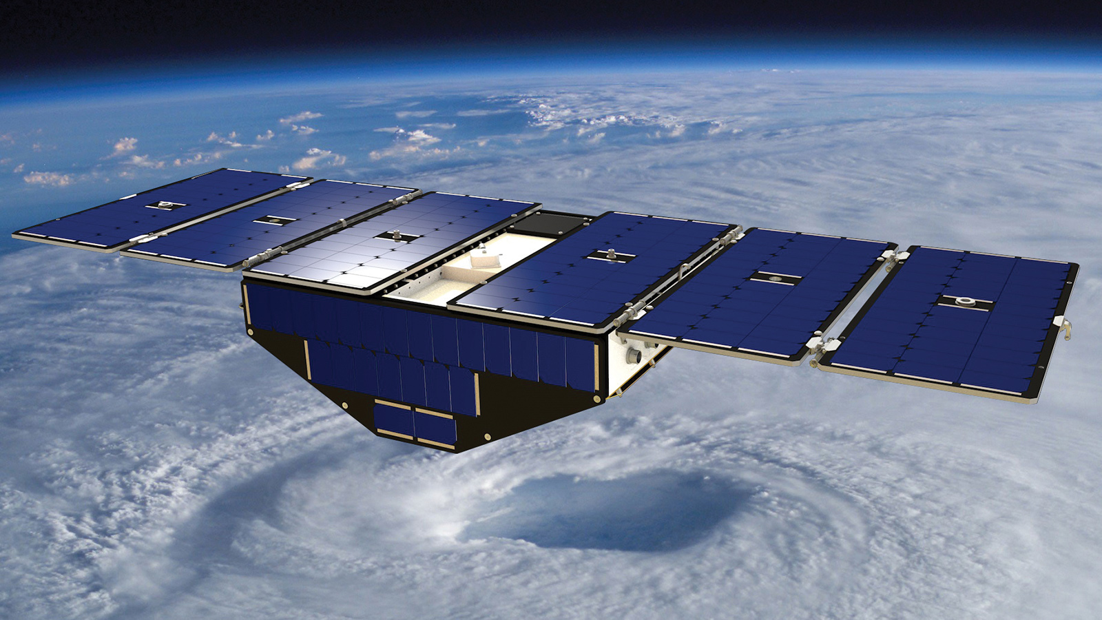
One such smallsat project is NASA’s Cyclone Global Navigation Satellite System, or CYGNSS. Launched in December 2016, CYGNSS consists of eight small satellites, each roughly the size of a person. The conventional method for measuring wind speeds is space-based radars, consisting of a transmitter and receiver, called scatterometers. CYGNSS sats, however, only have receivers, cutting down on costs. They measure wave height, an indicator of wind speed, by catching GPS signals that have bounced off the surface of the ocean and passed through the hurricane.
The GPS microwave frequency of 1.575 gigahertz travels well through clouds and rain. This approach lets CYGNSS uniquely look directly into the core of a hurricane, around its eye, where winds are strongest and storms draw much of their power. “All previous methods of measuring ocean surface winds couldn’t measure right in the center of the hurricane because the rain is too heavy,” says Chris Ruf, principal investigator of CYGNSS and a professor of climate and space science at the University of Michigan.
Because it consists of eight satellites whizzing around the planet instead of one, CYGNSS further benefits forecasters by providing frequent check-ins on hurricanes every several hours — better than the scrutiny that the low-altitude, polar-orbiters can offer, and much closer to the action than geostationary satellites like GOES. CYGNSS “lets us capture a storm’s rapid intensification phase, which often lasts maybe 24 to 36 hours,” says Ruf. “Standard polar orbiters only come back around [to a particular storm] every two to three days, so you miss it.”
Ruf says that initial results with CYGNSS of the highly active 2017 hurricane season suggest ingesting its data into state-of-the-art hurricane modeling does improve accuracy of storm behavior.
CYGNSS is hardly alone in testing the scientific value of smallsats. RainCube, a shoebox-sized cubesat, is testing a compact kind of radar. It was deployed from the International Space Station and in August took images for the first time of a brewing storm over Mexico. Another sat, TEMPEST-D, put a mini-microwave radiometer through its paces in September, peering through clouds to visualize rainfall within Hurricane Florence.
As with CYGNSS, smallsat fleets of RainCubes and TEMPESTs could reveal storms’ heretofore well-guarded secrets and in virtually real time. Paired with drones, plus continued advances by crewed aircraft and conventional satellites, researchers have reason to hope that intensification and behavior — all in the light of climate change — will soon be as readily foreseeable as hurricane tracks.
“We’re going to go after the storm from all angles,” says Ruf. “That’s the master plan.”
“Rapid intensification is one of the top challenges in hurricane science. There is growing evidence that climate change will impact the occurrence and intensity of storms, but one question is whether we are seeing those effects now with storms like Harvey, Maria and Michael, or whether those influences won’t emerge until later in this century.”
Scott Braun, NASA research meteorologist