Momentum builds to give FAA control of space traffic
A new U.S. radar is taking shape on a spit of land in the Pacific Ocean. This radar and companions at 12 other sites will send a harmless curtain of radio frequencies into space. Each time a satellite or chunk of debris passes through the curtain, some of the radio energy will be reflected back to the ground. The Space Fence will spot debris or satellites as small as a golf ball, a considerable improvement over today’s softball-sized limit. That’s good, because miniature satellites are all the rage, and even a tiny object traveling 29,000 kph (nine times faster than the average rifle bullet) can destroy a spacecraft.
Here’s the bad news. A team of experts somewhere will have to track 10 times as many objects as before and apply algorithms to estimate when or if any of these previously undetectable objects will collide with each other or spacecraft.
“It will be like putting on glasses and seeing a lot more scary things,” says one Air Force official.
If nothing changes, that team of experts would be headed by the Air Force. Just as now, possible conjunctions must be anticipated; spacecraft operators must be asked to maneuver or not to maneuver. Consensus is growing in the U.S. that the Air Force should stop acting like the world’s space traffic cop and concentrate instead on figuring out what China, Russia or others are up to militarily in space and figuring out how to counter that if necessary.
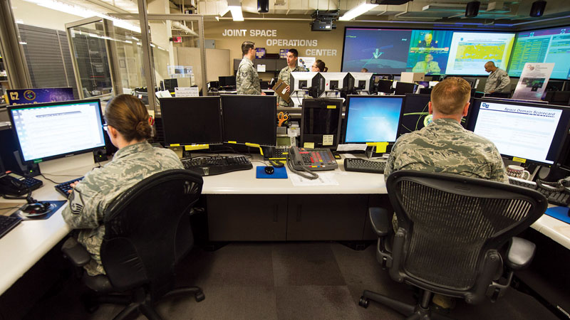
Specifically, the Defense Department wants to hand off its satellite tracking data and traffic management duties to the FAA but keep its Joint Space Operations Center, or JSpOC, pronounced Jay-Spock, a gymnasium-sized room in California where specialists from the service branches depict the tracks and identities of space objects on large screens for commanders. The Pentagon says the FAA “has the right mechanisms in place” to provide guidelines for safe operations in space. The FAA’s Office of Commercial Space Transportation likes the idea, too.
“We are ready to roll up our sleeves, partner with the Defense Department and other stakeholders to see if we can make that work,” says the FAA’s George Nield, associate administrator for commercial space transportation.
What this adds up to is a race of sorts. A tidal wave of data is coming, and decisions about personnel, data sharing and funding will need to be made quickly — in bureaucratic time — if a transition to the FAA is to happen before the wave breaks. The Space Fence is due for completion in 2019, and the marketplace is loaded with proposals for vast constellations of small satellites for imaging, communications and weather forecasting. OneWeb, Boeing and SpaceX alone plan to launch about 6,000 small satellites within the next 15 years.
As for the shift to civilian space traffic management, “This is not the kind of thing where you can snap your fingers and switch it overnight,” the Air Force’s Winston Beauchamp told reporters in September during a briefing at the AIAA Space conference in Long Beach, California.
Struggling to keep up
Why the eagerness for change? For decades, the Air Force has been responsible for tracking satellites and orbital debris with the Space Surveillance Network, a worldwide array of radars and ground telescopes, including a version of the Space Fence that was shut down in 2013 as well as the new one to come. The locations and identities of spacecraft, if that can be determined, are put into a catalog. The job of parsing this data and warning satellite operators around the world about possible collisions seemed manageable when the United States, Russia and China were the only ones launching spacecraft. Over the past few years, falling launch prices and miniature electronics have led to a surge in satellite activity that promises to double, triple or quadruple the number of spacecraft in orbit within a decade.
Already, the Air Force feels overwhelmed. The Space Surveillance Network takes more than 400,000 snapshots each day showing the orbital position of objects. In 2015, the JSpOC sent nearly 1.3 million emails to government and commercial satellite operators warning them of close approaches. Those warnings led to at least 148 collision avoidance maneuvers last year, including four by the International Space Station.
At the same time, potential U.S. adversaries are working on weapons that threaten the satellites the U.S. military relies on for communications, navigation, surveillance and missile warning. The Air Force would rather focus on those military matters by characterizing a spacecraft into its type, discerning its capabilities and determining the intent of its owner.
No matter who has the job, heavy space traffic makes it more likely that pieces of space debris will collide with satellites or spent rocket stages. As NASA’s Donald Kessler pointed out in a 1978 paper, each collision increases the chance of additional collisions, which could lead to a cascade and a dangerous belt of debris that would ruin some orbits or threaten satellites traveling through the area into higher orbits.
Even once the Air Force makes the handoff, it will continue to keep close tabs on everything in orbit, because that’s essential to protecting its spacecraft and those of U.S. allies.
“The Defense Department needs to understand what’s up there, how its behaving and what it can do in terms of a threat,” explains Moriba Jah, the University of Arizona’s director of space object behavioral sciences and a former principal investigator at the Air Force Research Laboratory. “But having the additional burden of informing planet Earth of all this is the piece that doesn’t make sense.”
The Air Force space surveillance expert was more blunt, saying, “The JSpOC will contribute, but we can’t be the only ones holding the bag.”
Tragedy of the commons
Until recently, satellite operators paid little thought to space traffic. They would note that there is a lot of empty space in space. That view is changing. Space is undeniably a big place, but more spacecraft than ever are poised for launch, and they will not be spread uniformly throughout Earth’s orbit. Instead, they will be clustered in specific kinds of orbits and in specific altitude ranges. Remote sensing satellite operators, for example, generally prefer polar orbits at altitudes of around 800 kilometers so spacecraft pass over farms, forests and cities at the same time every day. That’s also an attractive orbit for communications satellites.
“We are now approaching the tragedy of the commons,” Jah says. “People are acting in complete self-interest without looking at the needs of the whole community.”
He hopes that all the attention on space traffic management will improve this situation. As an example, Jah cites the international rules describing how satellite operators should handle satellites when their missions end. The Inter-Agency Space Debris Coordination Committee publishes debris mitigation guidelines, which have said satellites should be positioned to either fall back into the atmosphere within 25 years or should be dispatched to “graveyard” orbits. Even those rules, which many debris experts say are far too lenient, are not strictly monitored or enforced.
Debris experts also say that space traffic collisions could be avoided more easily if a catalog showed the size and shape of various objects. If satellite operators knew whether space debris headed for their satellite was a rocket body, a dead satellite or a bolt, they would have a better idea of the severity of the threat and how quickly they should move their spacecraft out of the way. Swerving rapidly requires a lot more fuel than a slow and steady maneuvering.
“More rigorous science is needed to help us fully understand the space traffic and orbital safety problem,” Jah says. “The 25-year rule was an ad hoc number that was settled upon because some folks felt 50 years was too long. In other words, it’s not based on any rigorous analysis that actually shows that 25 years is a magic number for debris mitigation.”
He suggests tailoring the rules. Massive spacecraft and large constellations should get out of the way quickly once their jobs are done, Jah says.
There are currently about 1,400 satellites in orbit that their owners can track, control and maneuver. That number is expected to grow quickly, but just how quickly is hard to tell. Entrepreneurs, established firms, universities and government agencies are raising money for 3,000 new satellites. Meanwhile, the International Telecommunication Union, the United Nations agency that dispenses radio spectrum and orbital slots, has received filings from satellite operators listing 10,000 to 11,000 potential new satellites.
“I wouldn’t bet that all the new satellite constellations will become reality, but some will,” says Paul Graziani, co-founder and CEO of Analytical Graphics Inc., which licenses software for modeling trajectories of objects in orbit and estimating the likelihood of collisions. “Regardless, smaller satellites are here to stay.”
Information explosion
Orbiting alongside the small satellites are half a million pieces of debris. They range from tiny paint chips and foam insulation (dangerous because of their velocities) to spent boosters and spacecraft, like the defunct Russian Cosmos satellite that crashed into an Iridium telecommunications satellite in 2009, creating a debris cloud.
That’s the type of collision the Air Force now tries to prevent by telling satellite operators when their spacecraft may be headed for other spacecraft or orbiting debris. Prior to the Cosmos-Iridium collision, the JSpOC focused primarily on military satellites. It was not tracking the Iridium constellation, so it could not warn Iridium Communications. That incident led to major changes. The JSpOC immediately began tracking the Iridium constellation. By June, four months after the collision, the Air Force was paying contractors to start designing the Space Fence. By the end of the year, the JSpOC was tracking all spacecraft in orbit, about 1,150 compared with the 120 military satellites it previously tracked. Since the Iridium-Cosmos collision, the Air Force also signed agreements to share space tracking data with 11 U.S. allies, two U.S. government agencies and 52 commercial firms. Air Force Space Command also boosted staffing in the JSpOC from 43 in 2009 to 56 now.
The string of new S-band radars Lockheed Martin is building on Kwajalein Atoll will help the Air Force track 200,000 objects instead of the 20,000 it now sees. At the same time, the Air Force is negotiating agreements with U.S. allies to share data gathered by foreign telescopes and sensors. Meanwhile, private companies are expanding their efforts to collect, process and share space data.
“We are certainly expecting an explosion in the information and the data we are going to have,” said Maj. Gen. David Thompson, vice commander of Air Force Space Command, at the AIAA Space conference in September.
“To be able to deal with it and manage it and still do the mission we have to do, we recognize that as a challenge.”
Unanswered questions
Instead of worrying about whether two cubesats are going to smash into each other in low Earth orbit — and if so, how to notify their owners — the Air Force wants to concentrate on protecting military satellites.
“Obviously, we have potential adversaries that recognize the importance of space to the U.S. and its allies from a national security position and are increasingly developing capabilities to attempt to deny that if we ever find ourselves in conflict,” Thompson said during the AIAA conference. “If we understand an adversary has a capability and intends to use it against us in space, how do we protect and defend our space assets? How do we prevent them from destroying or damaging those capabilities?”
The Air Force will be able to focus on those questions better once it hands off some of its space traffic management duties to the FAA.
Transportation Secretary Anthony Foxx, whose department includes the FAA, told Congress in a September report that the FAA could take on space data processing and issue safety warnings if it gets congressional authority; protection from lawsuits that might arise from this role; and a $20 million initial expenditure for additional personnel and computer systems.
Nield, of the FAA’s space office, thinks it would be wise to begin with a pilot program to practice collecting, processing and sharing space traffic data while protecting information the military does not want to share. Meanwhile, the Air Force would continue in its current role, including issuing collision warnings.
“That [pilot] will allow us to try some things and get our hands dirty,” Nield says. “To the extent that there are remaining questions about cost or schedule or the accuracy of the data, we can address those. If it’s just not going to work, we can pull the plug and say, ‘We tried.'”
But no one expects this transition to fail. The stakes are too high.
“When you are dealing with national security, there always needs to be a sense of urgency,” says U.S. Rep. Jim Bridenstine, R-Oklahoma. He proposed legislation in April that would give the FAA authority to take on some of the work currently performed by the Air Force. “We are seeing a proliferation of threats from nation states and non-nation state actors that we didn’t foresee even five years ago.”
The FAA Office of Commercial Space Transportation could “provide information and services to civil, commercial and foreign actors, while the DoD focuses on what it’s good at: fighting and winning wars,” he says.
Bridenstine agrees that an FAA pilot program is the appropriate first step, adding that Congress will need to provide the FAA with authority to proceed, and congressional appropriators will have to find funding for the pilot by identifying offsets, which means spending cuts elsewhere in the budget to ensure the new program does not add to the federal deficit.
Through the pilot, the FAA could demonstrate its ability to provide satellite operators with warnings that are as good or better than they currently receive from the JSpOC. If the pilot is successful, the FAA could request funding to expand this work. Then, it will be up to Congress to give the FAA the appropriate authority and funding to carry it out, Bridenstine says.
Meanwhile, work continues on the Space Fence. On one level, “ignorance may be bliss” when it comes to objects in space, Thompson, the vice commander, said during the AIAA conference, but on another level, the Space Fence promises to improve spaceflight safety. The job will just get that much bigger. ★
CLOSE CALLS
In 2015, the FAA’s Joint Space Operations Center sent nearly 1.3 million emails to government and commercial satellite operators warning them of close approaches. Those warnings led to at least 148 collision avoidance maneuvers.
EVASIVE MANEUVERS
Satellites and the International Space Station must sometimes be steered out of the path of debris. Since its launch in 2014, Orbital ATK has maneuvered the Orbiting Climate Observatory-2 out of the path of debris six times, says Program Manager Joseph Bushman. The company operates OCO-2 for NASA from Dulles, Virginia. NASA maneuvered the space station four times in 2015.
“The 25-year rule was an ad hoc number that was settled upon because some folks felt 50 years was too long.”
Moriba Jah, the University of Arizona’s director of space object behavioral sciences and a former principal investigator at the Air Force Research Laboratory, on the timeline for spacecraft to stay in space