From ‘monitoring’ to action
By Hope Hodge Seck|April 2024
Methane is invisible, odorless in low concentrations and a byproduct of raising cattle and drilling gas and oil for energy. The arrival of MethaneSAT in orbit last month has sparked new hopes among environmentalists that businesses will soon be held accountable for their methane emissions and that this will prompt them to improve their self-monitoring. Hope Hodge Seck looks at the fine points of identifying polluters from space.
When researchers installed a chemical-detection sensor in a Twin Otter turboprop and flew it over an active oil field for the first time, Karen Jones was astonished. The sensor, designed and built by the federally funded Aerospace Corp., detected invisible methane gas seeping from the field’s oil wells. The plume was large enough to power 17,000 homes, ranking it as a super emitter. That flight was in 2015 in San Joaquin Valley, California. Flights over two other fields in the valley through 2018 showed they, too, were super emitters.
For Jones, a policy analyst at Aerospace Corp.’s Center for Space Policy and Strategy, the flights added up to a career moment, given that methane is a greenhouse gas whose warming impact is 28 times greater than that of carbon dioxide. Jones and a co-author wrote a paper that was published by the center, “Mapping Methane Super-Emitters in Oil and Gas Fields: A Tiered Remote Sensing Strategy.”
“The oil companies will say, ‘Oh, that’s just vapor, it’s just steam,’” Jones says. “No, you need to get a molecular signature to basically say, ‘You’ve got methane.’”
She and her co-author were able to get that signature for the fields in San Joaquin Valley, but one can’t fly a Twin Otter everywhere. Satellites were helping, but they did not have the resolution to alert polluters or hold them responsible if they did not act on the information.
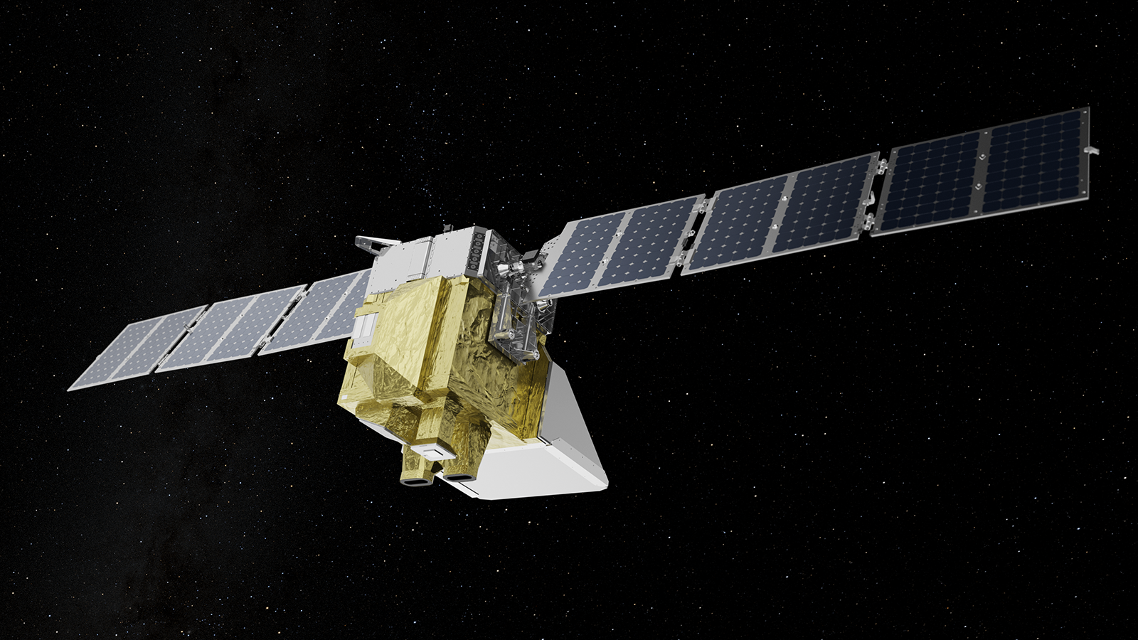
Enter MethaneSAT, a washing machine-sized satellite launched last month for the New York-based Environmental Defense Fund in partnership with Google, Harvard University, the Smithsonian Institution and others. Now in a several-month calibration phase, MethaneSAT aims to identify specific oil and gas methane emission sources like the fields in San Joaquin Valley.
If it succeeds, MethaneSAT could help dispel a sense of disillusionment that some in the field of environmental monitoring via satellites have felt over the value of their work.
In 2021, Jones published another paper, this one “out of frustration” over the mammoth investments in satellite environmental monitoring that seemed rarely to lead to action from regulators or polluters. At the time, she counted some 890 Earth observation satellites in orbit, about a quarter of all operational satellites. Another 3,000 EO satellites and smallsats, she wrote, were due for launch by 2028. Even with all those satellites and their data, a “regulatory paradigm shift” had not yet taken place from a near total reliance on self-reporting, sometimes based on flimsy evidence, to one based on objective, peer-reviewed scientific observations.
The employment of satellites to detect atmospheric and surface pollution is nothing new. Since 2001, West Virginia-based SkyTruth has used images from the NASA-U.S. Geological Survey Landsat program to watch ocean oil slicks and fracking operations. Carbon dioxide has had a dedicated tracker in NASA’s Orbiting Carbon Observatory program for a decade; NASA’s TEMPO, or Tropospheric Emissions: Monitoring of Pollution, satellite has been delivering hourly reports on greenhouse gases ozone, nitrogen dioxide and formaldehyde mainly over North America for a year.
This ever-better picture of world pollution, as Jones noted, hasn’t yet produced the aggressive crackdown on sources that advocates hope for. There have been unwilling enforcers, missing partnerships for action and nonspecific objectives. MethaneSAT’s engineers believe their spacecraft is poised to overcome all that.
Among the hundreds of Earth observation satellites in orbit, MethaneSAT is unique: It’s the only climate-measuring satellite designed and funded by a nonprofit organization — the Environmental Defense Fund, or EDF — rather than a government agency or a private company, says Peter Vedder, the satellite’s senior director of mission systems.
Its target is a greenhouse gas that’s tied closely to human needs for food and energy. The largest contributor to the estimated doubling of methane emissions compared to 200 years ago is agriculture, as methane is a digestion byproduct of what are now more than 1.5 billion cattle worldwide and 89 million in the United States alone. Methane is also released at multiple points during oil and gas drilling operations — the second-largest contributor to methane emissions. Excess methane-rich natural gas is often vented or burned, not always completely, during well completion and maintenance for safety reasons, or to get rid of a product the companies don’t have the means to sell. There are also “fugitive emissions” that happen when methane escapes through faulty or leaking equipment and, as Jones discovered, as a result of heat and pressure applied in the extraction process.
In addition to being 28 times better than carbon dioxide at trapping heat in the atmosphere, methane made up 12% of all greenhouse gas emissions in 2021.
“Because methane is both a powerful greenhouse gas and short-lived compared to carbon dioxide,” the U.S. Environmental Protection Agency states, “achieving significant reductions would have a rapid and significant effect on atmospheric warming potential.”
The $88 million MethaneSAT is funded by a $16 million grant from the government of New Zealand and EDF donors, including the Bezos Earth Fund, Arnold Ventures, the Robertson Foundation and the TED Audacious Project. The goal is an aggressive one: Achieve a 75% reduction in oil and gas-related methane emissions by 2030. The team projects that this goal can be met by employing better leak detection and equipment. For that reason, the prospect of reducing oil- and gas-related methane is widely acknowledged as the “low-hanging fruit” in the world of greenhouse gas mitigation, since it’s less complex than cutting back agricultural emissions. Through delivering information about methane leak sources discovered by the satellite to regulators and company leaders, and making methane heat maps available to the public to encourage citizen activism, they hope to create the kind of public pressure that will provoke change.
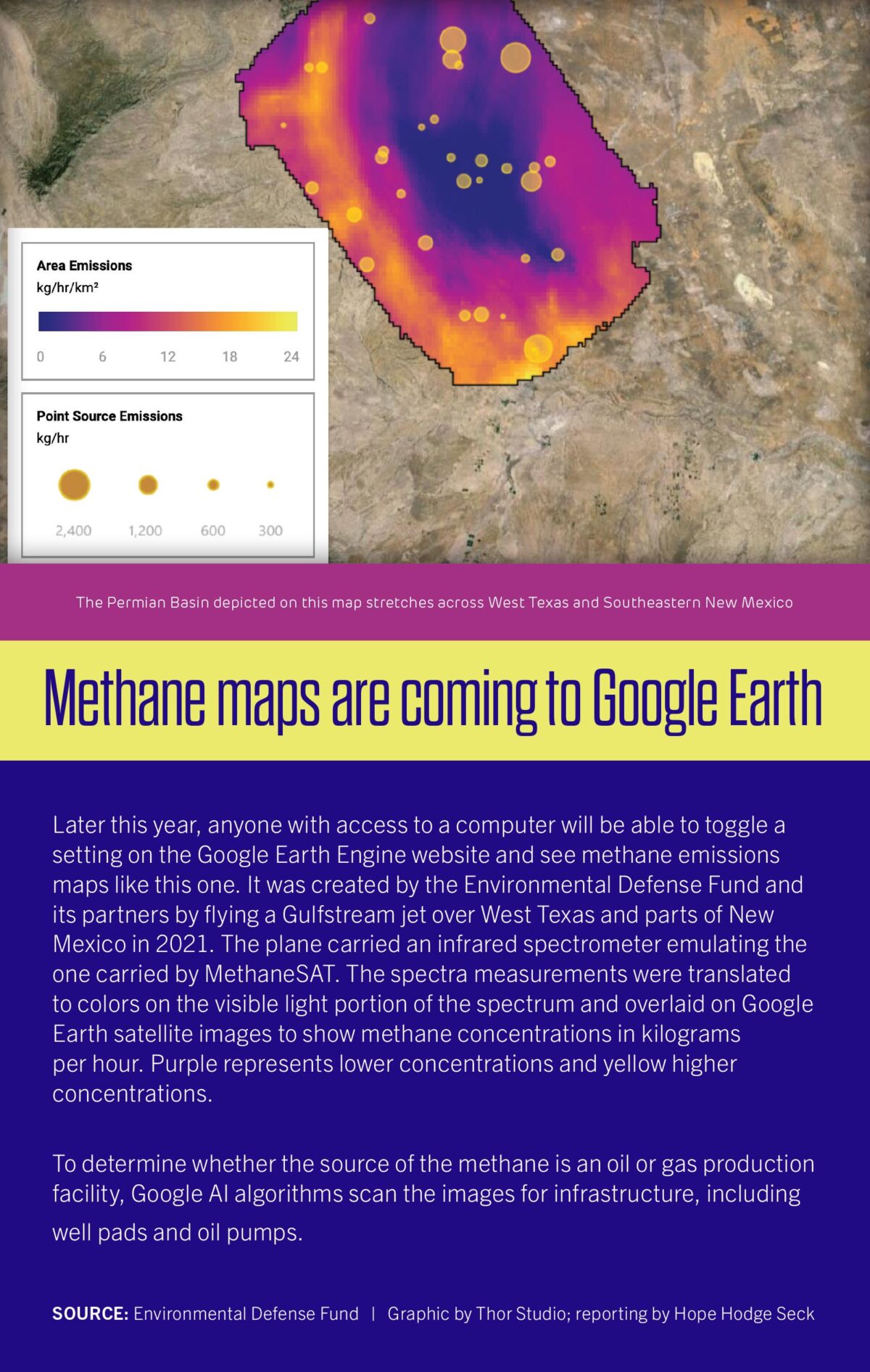
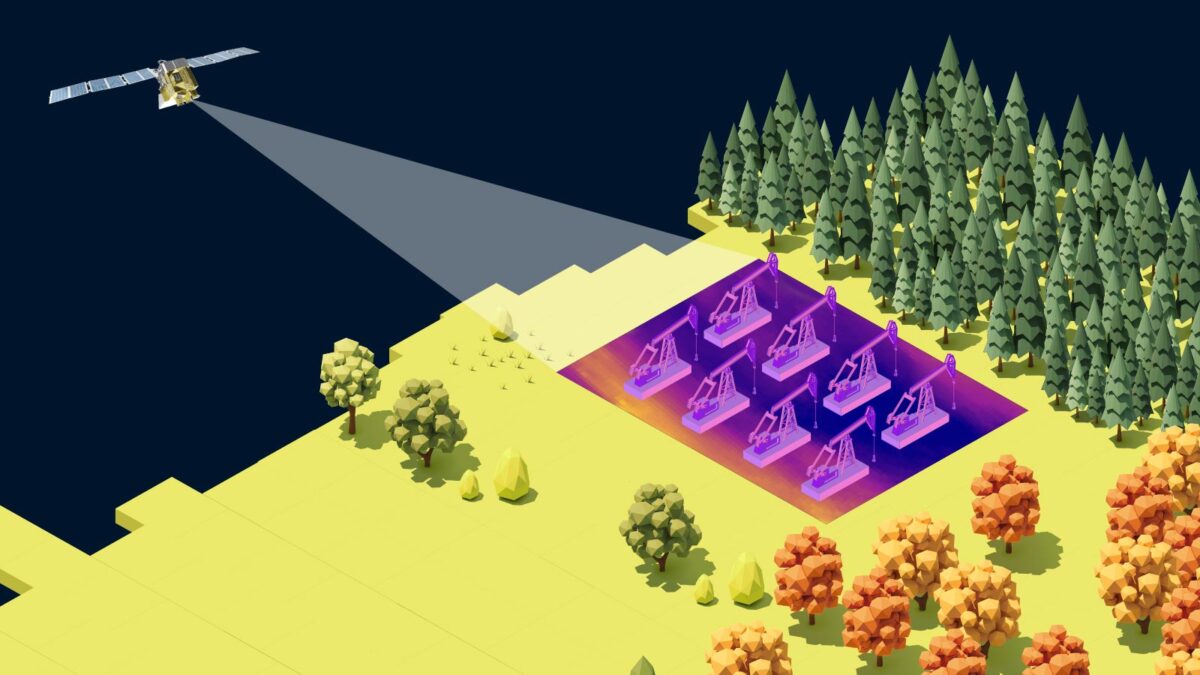
MethaneSAT orbits from pole to pole in a sun-synchronous orbit, so that it’s always in daylight, and will screen reflected sunlight for the unique methane wavelength pattern, much like looking for a specific fingerprint. On the ground, the MethaneSAT team will overlay methane readings onto 3D images generated by the Google Earth Engine under a partnership with the Google Cloud service. The result will be a global searchable map showing emission rates and concentrations. The satellite can take readings at up to 25 area locations per day selected by the MethaneSAT team. While they plan to vary the locations to capture a global picture of methane emissions, they also expect to have the satellite return to regions with emissions every few days to calculate the rate and progression of leaks.
The satellite’s ability to capture 200 square kilometers in a single collection makes it an “area mapper,” Vedder says, capable of capturing entire petroleum basins, the large, low-lying geological beds containing oil and gas reservoirs. If all goes as planned, it will detect and measure emissions from four-fifths of the world’s oil and gas producers. Its ability to measure methane concentrations as small as three parts per billion — the equivalent of three drops of water in a backyard swimming pool — will allow it to pinpoint methane points of origin and map the outer reaches of plumes.
This scope and specificity distinguishes MethaneSAT in the universe of climate-measuring satellites, which includes no fewer than a dozen methane monitors. Vedder acknowledges the crowded field but maintains that nothing in the sky can do what MethaneSAT will. “Global mappers,” like the European Space Agency’s TROPOspheric Monitoring Instrument, can detect methane, he says, but not at a high enough resolution to find origin points and pin the blame on polluters.
“It’s a fuzzy image, kind of like your peripheral vision,” Vedder says. “You can sense something is there, but you can’t make out the details.”
By contrast, he says, “point source imagers,” like ESA’s GHGSat constellation, deliver high-resolution pictures, but of a narrow and predetermined region.
“It’s kind of like looking through a soda straw,” he says. “So you can measure the methane right there, but you can miss bigger emissions nearby.”
To MethaneSAT’s backers, the link to climate action is clear: The satellite will deliver specific “actionable information” about the sources of methane pollution to a ground processing center. Point sources as small as a house will be identified, and the total quantity and hourly rate of emissions will be shown. Separately, an EDF team is being formed to report methane sources to U.S. regulators and oil and gas companies, and engage international and global organizations about how they can do the same.
The U.S. and other governments have largely relied on companies to fess up about their methane footprints. “Self-reporting doesn’t necessarily mean that these companies are intentionally lying or trying to fail the truth,”Jones says. The gas is invisible and odorless in low concentrations, so it’s possible that “they may not know.”
Admittedly, it’s not always easy to demonstrate how a better picture of global pollution has directly led to better policy or more effective partnerships around limiting or cutting emissions. Scientists who work with Earth-watching satellites are fond of the phrase “You can’t manage what you can’t measure,” meaning they view the global picture as a necessary precursor to any kind of meaningful mitigation action. But ambitious satellite projects have come and gone without having the dramatic emissions-reducing impact predicted at their launch. MethaneSAT has a short window to make a big difference: Its projected service life is between two and five years, according to instrument-maker BAE Systems.
In terms of inspiration, NASA’s Orbiting Carbon Observatory-2 and 3 satellites (the first OCO satellite was lost in a launch failure) has been the provider, though for carbon dioxide.
One lesson concerns data continuity, which is a particular challenge in the world of satellite pollution monitoring, as satellites are complex and costly enterprises that typically require years of planning and development.
Abhishek Chatterjee, the project scientist for the OCO program since 2022, wonders what will replace what he calls “the gold standard” of carbon-measuring satellites when they finally cease operations. Both OCO-2, launched in 2014 to a sun-synchronous orbit, and OCO-3, a sedan-sized instrument fitted like a Lego block to the outside of the International Space Station in 2019, have far exceeded their anticipated service lives of two to three years. While NASA is considering a follow-on carbon-measuring satellite, an OCO-4 has yet to be approved amid competing budgets and priorities.
The OCO satellites measure near-infrared sunlight, sorting CO2 by its wavelength absorption with instrument sensitivity capable of detecting less than one part per million and delivering detailed carbon “snapshots” of entire urban regions to a handful of ground stations about once a day. With this information, NASA scientists have developed inferred, realistic CO2 budgets for approximately 100 countries to keep them aligned with Paris Agreement targets, based on a five-year analysis of their emissions. Some countries, like Japan and the United Kingdom, had already created their own legally binding carbon budgets; about two dozen others have established some form of carbon tax.
Chatterjee also pointed to a first-of-its-kind study, published in 2021, based on OCO-3 readings of the Los Angeles “megacity,” one of the world’s top five CO2 emitters. CO2 emissions were broken down by source, from aircraft to vehicles to oil drilling infrastructure. Results showed just how much the region’s carbon footprint had been diminished during the covid-19 lockdown by thousands of cars staying off the freeways. The effort made headlines, and the already climate-conscious California legislature last year became the first in the nation to pass a law requiring companies to disclose their greenhouse gas emissions.
Could MethaneSAT have a similar impact?
EDF’s Vedder contends that the relatively recent understanding of methane’s environmental impact, plus the concentrated nature of its emission sources, makes a comparison to the hydrofluorocarbons used in cooling and refrigeration more apt. After these short-lived but potent greenhouse gases were shown to contribute to global warming, the U.S. moved aggressively to phase them out, with the EPA last year fully banning the use of hydrofluorocarbons in new products.
“Methane’s really only been recognized as a major contributor to global warming in the past decade, 15 years,” Vedder says. “And so now we’re starting to ramp up to have the tools to be able to provide the information to make those mitigation efforts.”
The 2023 discovery of a massive methane leak from a natural gas well blowout in Kazakhstan demonstrates both the potential of satellite observation and its limitations. Brought to light by satellite observations reported by French environmental monitoring organization Kayrros, the leak belched enough methane into the atmosphere to match the emissions of 717,000 vehicles driven for a year, according to a Financial Times calculation.
The reporting triggered international outrage. Following a summit on mitigating greenhouse gases at the end of the year, Kazakhstan released a joint statement with its ally the U.S., committing to methane abatement goals. The company that owns the super-emitter oil field, however, denied the existence of the leak. As punishment, it received a negligible fine equivalent to about $780,000 from the government of Kazakhstan, underscoring the constraints the global community faces in holding major polluters accountable.
MethaneSAT’s team is counting on open-source reporting and public pressure helping to drive climate-saving actions in places where regulators and policymakers might otherwise lack motivation. Better information-processing tools such as machine learning and cloud computing are making it easier to deliver timely and comprehensible information to the public. MethaneSAT’s partnership with Google Cloud is built on a belief that allowing any internet user to zoom in on methane polluters from a desktop computer will make the problem matter more to people, thus driving them to demand action.
Mark Brownstein, EDF’s senior vice president, has said MethaneSAT’s pollution maps will allow the public to “name and shame” pollution perpetrators but also recognize companies that are reducing their emissions. This concept of calling out villains and heroes is behind climate activists’ best hopes for the future impact of global pollution trackers.
“To paraphrase an ocean conservation CEO that I had the pleasure of working with,” says John Amos, founder of the environmental watchdog SkyTruth, “‘You can give governments all the best tools in the world, and they’re not going to do a thing in the absence of public pressure.’”